IMAGES TAKEN NEAR TO
Six Ashes, BRIDGNORTH, WV15 6EP
Introduction
This page details the photographs taken nearby to WV15 6EP by members of the Geograph project.
The Geograph project started in 2005 with the aim of publishing, organising and preserving representative images for every square kilometre of Great Britain, Ireland and the Isle of Man.

There are currently over 7.5m images from over14,400 individuals and you can help contribute to the project by visiting https://www.geograph.org.uk
Image Map
Images are licensed for reuse under creativecommons.org/licenses/by-sa/2.0
Notes
- Clicking on the map will re-center to the selected point.
- The higher the marker number, the further away the image location is from the centre of the postcode.
Image Listing (5 Images Found)
Images are licensed for reuse under creativecommons.org/licenses/by-sa/2.0
Image
Details
Distance
3
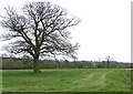
Towards High Barns Farm from the lane near Lindridge
Grazing land west of High Barns Farm.
Image: © Richard Law
Taken: 2 Aug 2012
0.21 miles
4
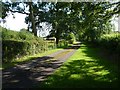
Evening sunshine on the road to Lanegreen
Image: © Richard Law
Taken: 2 Aug 2012
0.24 miles
5
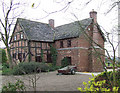
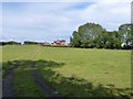
Beauty Bank Farmhouse west of Coxgreen in Staffordshire
Just over into Shropshire, this farmhouse has been expertly renovated and extended, including the use of local sandstone materials. Superb!
Image: © Roger Kidd
Taken: 9 Apr 2007
0.25 miles