IMAGES TAKEN NEAR TO
Well Meadow, BRIDGNORTH, WV15 6DH
Introduction
This page details the photographs taken nearby to Well Meadow, WV15 6DH by members of the Geograph project.
The Geograph project started in 2005 with the aim of publishing, organising and preserving representative images for every square kilometre of Great Britain, Ireland and the Isle of Man.

There are currently over 7.5m images from over14,400 individuals and you can help contribute to the project by visiting https://www.geograph.org.uk
Image Map
Images are licensed for reuse under creativecommons.org/licenses/by-sa/2.0
Notes
- Clicking on the map will re-center to the selected point.
- The higher the marker number, the further away the image location is from the centre of the postcode.
Image Listing (253 Images Found)
Images are licensed for reuse under creativecommons.org/licenses/by-sa/2.0
Image
Details
Distance
1
Severn-side houses
In the Low Town of Bridgnorth.
Image: © James Allan
Taken: 30 Mar 2016
0.05 miles
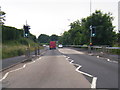
3
Ford car showroom, Bridgnorth
On Hospital Street, Low Town, Bridgnorth. Opposite is a short terrace of brick cottages.
Image: © David Smith
Taken: 23 Jul 2013
0.11 miles
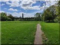
4
The Geopark Way along the River Severn, Bridgnorth
Image: © Mat Fascione
Taken: 7 May 2023
0.13 miles
5
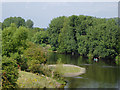
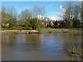
The River Severn south of Bridgnorth, Shropshire
Looking upstream from the A458 road bridge.
Image: © Roger D Kidd
Taken: 22 Aug 2015
0.13 miles
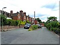
6
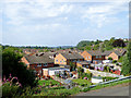
Housing in Bridgnorth Low Town, Shropshire
This housing estate of detached and semi-detached houses centres on Wellmeadow, between Kidderminster Road and the River Severn.
Image: © Roger D Kidd
Taken: 22 Aug 2015
0.14 miles
8
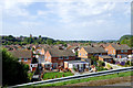
Across the rooftops of Bridgnorth Low Town, Shropshire
This is looking across the housing centred round Wellmeadow. On the other side of the (hidden) River Severn is the steep slope up to Bridgnorth High Town. The sandstone tower of St Leonard's Church can be seen on the skyline.
Image: © Roger D Kidd
Taken: 22 Aug 2015
0.14 miles
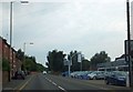
9
Bernards Hill
The last building on the left is the Hare & Hounds pub. Image
Image: © P L Chadwick
Taken: 6 Jul 2010
0.14 miles
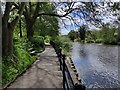
10
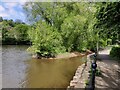
The Bylet on the River Severn
The Bylet is a small island in the River Severn at Bridgnorth. It contains a bowling club, connected to Severn Side South by the Terriers Bridge. The path on the right is the Geopark Way.
Image: © Mat Fascione
Taken: 7 May 2023
0.15 miles