IMAGES TAKEN NEAR TO
Hillside Avenue, BRIDGNORTH, WV15 6BS
Introduction
This page details the photographs taken nearby to Hillside Avenue, WV15 6BS by members of the Geograph project.
The Geograph project started in 2005 with the aim of publishing, organising and preserving representative images for every square kilometre of Great Britain, Ireland and the Isle of Man.

There are currently over 7.5m images from over14,400 individuals and you can help contribute to the project by visiting https://www.geograph.org.uk
Image Map
Images are licensed for reuse under creativecommons.org/licenses/by-sa/2.0
Notes
- Clicking on the map will re-center to the selected point.
- The higher the marker number, the further away the image location is from the centre of the postcode.
Image Listing (19 Images Found)
Images are licensed for reuse under creativecommons.org/licenses/by-sa/2.0
Image
Details
Distance
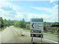
2
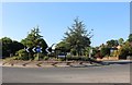
Roundabout on Kidderminster Road, Bridgnorth
Image: © David Howard
Taken: 30 May 2020
0.07 miles
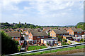
4
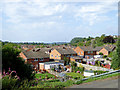
Housing in Bridgnorth Low Town, Shropshire
This housing estate of detached and semi-detached houses centres on Wellmeadow, between Kidderminster Road and the River Severn.
Image: © Roger D Kidd
Taken: 22 Aug 2015
0.11 miles
5
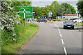
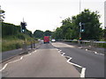
View from A442 along A458 from roundabout
Image: © John Firth
Taken: 17 May 2010
0.12 miles
6
Across the rooftops of Bridgnorth Low Town, Shropshire
This is looking across the housing centred round Wellmeadow. On the other side of the (hidden) River Severn is the steep slope up to Bridgnorth High Town. The sandstone tower of St Leonard's Church can be seen on the skyline.
Image: © Roger D Kidd
Taken: 22 Aug 2015
0.12 miles
7
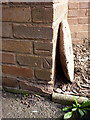
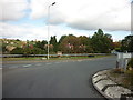
OS benchmark - Bridgnorth, 29 Kidderminster Road
An OS cutmark on the side of no 29 Kidderminster Road; originally levelled at 41.383m above Ordnance Datum newlyn.
Image: © Richard Law
Taken: 4 May 2014
0.13 miles
10
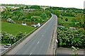
Bridgnorth Bypass crossing the River Severn, Shropshire
Viewed by looking east from a passing Severn Valley Railway train.
The A458 (from Shrewsbury) leads to Stourbridge, and via the A454 to Wolverhampton. The bypass was opened in 1985. The river flows from left to right.
Image: © Roger Kidd
Taken: 14 May 2014
0.18 miles