IMAGES TAKEN NEAR TO
Severn Street, BRIDGNORTH, WV15 6BB
Introduction
This page details the photographs taken nearby to Severn Street, WV15 6BB by members of the Geograph project.
The Geograph project started in 2005 with the aim of publishing, organising and preserving representative images for every square kilometre of Great Britain, Ireland and the Isle of Man.

There are currently over 7.5m images from over14,400 individuals and you can help contribute to the project by visiting https://www.geograph.org.uk
Image Map
Images are licensed for reuse under creativecommons.org/licenses/by-sa/2.0
Notes
- Clicking on the map will re-center to the selected point.
- The higher the marker number, the further away the image location is from the centre of the postcode.
Image Listing (570 Images Found)
Images are licensed for reuse under creativecommons.org/licenses/by-sa/2.0
Image
Details
Distance
1
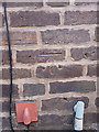
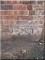
OS benchmark - Bridgnorth, nos 9 & 10, Severn Street
OS cutmark on the frontage between two houses on Severn Street; originally levelled at 33.583m above Ordnance Datum Newlyn.
Image: © Richard Law
Taken: 30 Dec 2013
0.01 miles
2
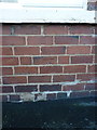
OS benchmark - Bridgnorth, no 50 Severn Street
OS cutmark on the front wall of no 50, Severn Street; originally levelled at 33.68m above Ordnance Datum Newlyn.
Image: © Richard Law
Taken: 30 Dec 2013
0.02 miles
4
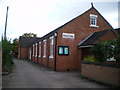
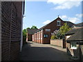
Bridgnorth - The People's Hall Evangelical Church
Located in St John Street, in Low Town, between the Post Office and The Falcon pub.
http://www.peoples-hall.org.uk/
Image: © Richard Law
Taken: 19 Sep 2010
0.05 miles
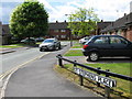
6
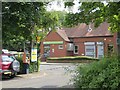
Car park, Low Town
Bridgnorth's Jobcentre is behind the bandit.
Image: © Richard Webb
Taken: 30 Jun 2014
0.06 miles
7
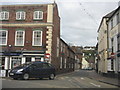
St Johns Street, Bridgnorth
A traditional building at number 16 St Johns Street in Bridgnorth's Low Town.
Image: © Mary and Angus Hogg
Taken: 14 Oct 2017
0.06 miles
9
OS benchmark - Bridgnorth, no 2 Severn Side South
An OS cutmark in the roadside wall outside no 2; originally levelled at 31.41m above Ordnance Datum Newlyn.
Image: © Richard Law
Taken: 25 Jan 2014
0.07 miles
10
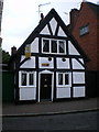
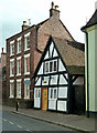
Elizabeth Cottage, Bridgnorth
A fine, if fairly small, half-timbered building in Low Town.
Image: © Richard Law
Taken: 19 Sep 2010
0.07 miles