IMAGES TAKEN NEAR TO
Stourbridge Road, BRIDGNORTH, WV15 6AS
Introduction
This page details the photographs taken nearby to Stourbridge Road, WV15 6AS by members of the Geograph project.
The Geograph project started in 2005 with the aim of publishing, organising and preserving representative images for every square kilometre of Great Britain, Ireland and the Isle of Man.

There are currently over 7.5m images from over14,400 individuals and you can help contribute to the project by visiting https://www.geograph.org.uk
Image Map
Images are licensed for reuse under creativecommons.org/licenses/by-sa/2.0
Notes
- Clicking on the map will re-center to the selected point.
- The higher the marker number, the further away the image location is from the centre of the postcode.
Image Listing (10 Images Found)
Images are licensed for reuse under creativecommons.org/licenses/by-sa/2.0
Image
Details
Distance
1

Industrial Premises, Bridgnorth, Shropshire
Image: © Roger Kidd
Taken: 5 May 2007
0.08 miles
2
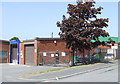
Industrial Units, Bridgnorth, Shropshire
There are several small and medium sized industrial units on the north side of the A458; some are not at present being used.
Image: © Roger Kidd
Taken: 5 May 2007
0.11 miles
3

Disused industrial buildings
Disused buildings next to the Craven Dunnill tiles site in Stourbridge Road.
Image: © John M
Taken: 5 May 2007
0.15 miles
4
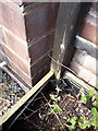
OS benchmark - Bridgnorth, 51 Stourbridge Road
An OS cutmark on the frontage of no 51 Stourbridge Road; originally levelled at 61.112m above Ordnance Datum Newlyn.
Image: © Richard Law
Taken: 4 May 2014
0.16 miles
5
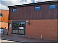
Kershaw's Café, Bridgnorth
Conveniently located for passing trade.
Image: © TCExplorer
Taken: 8 Jun 2024
0.16 miles
6
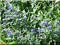
Green Alkanet, near Danesford, Shropshire
This pretty blue flowered plant grows in large colonies on grass verges in this area.
Image: © Roger Kidd
Taken: 5 May 2007
0.19 miles
7
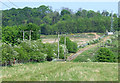
Poor Land near Bridgnorth, Shropshire
Demolition and redevelopment of industrial sites is taking place in this area adjacent to open countryside. The thin sandy soil layer barely supports grazing quality grass, though the coppice on the scarp seems well enough established.
Image: © Roger Kidd
Taken: 5 May 2007
0.20 miles
8
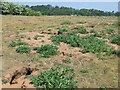
Rough Ground and Rabbit Holes, Danesford, Shropshire
The soil layer is so shallow, crumbly and sandy that it barely supports grass for grazing. Rabbit burrows are plentiful.
Image: © Roger Kidd
Taken: 5 May 2007
0.22 miles
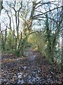
10
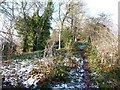
Footpath along the top of Hermitage Hill
Image: © Richard Law
Taken: 5 Dec 2010
0.24 miles