IMAGES TAKEN NEAR TO
Quatford, BRIDGNORTH, WV15 5QB
Introduction
This page details the photographs taken nearby to WV15 5QB by members of the Geograph project.
The Geograph project started in 2005 with the aim of publishing, organising and preserving representative images for every square kilometre of Great Britain, Ireland and the Isle of Man.

There are currently over 7.5m images from over14,400 individuals and you can help contribute to the project by visiting https://www.geograph.org.uk
Image Map
Images are licensed for reuse under creativecommons.org/licenses/by-sa/2.0
Notes
- Clicking on the map will re-center to the selected point.
- The higher the marker number, the further away the image location is from the centre of the postcode.
Image Listing (5 Images Found)
Images are licensed for reuse under creativecommons.org/licenses/by-sa/2.0
Image
Details
Distance
4
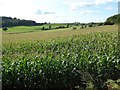
A field of maize
A field of maize near Morfevalley.
Image: © Philip Halling
Taken: 15 Aug 2017
0.19 miles
5
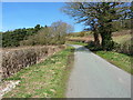
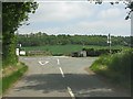
About to turn steep
At the base of the steep Morfevalley scarp, the road just round the bend goes sharply upwards for a couple of hundred yards.
Image: © Richard Law
Taken: 6 Apr 2015
0.24 miles