IMAGES TAKEN NEAR TO
Hartlebury, BRIDGNORTH, WV15 5LX
Introduction
This page details the photographs taken nearby to WV15 5LX by members of the Geograph project.
The Geograph project started in 2005 with the aim of publishing, organising and preserving representative images for every square kilometre of Great Britain, Ireland and the Isle of Man.

There are currently over 7.5m images from over14,400 individuals and you can help contribute to the project by visiting https://www.geograph.org.uk
Image Map
Images are licensed for reuse under creativecommons.org/licenses/by-sa/2.0
Notes
- Clicking on the map will re-center to the selected point.
- The higher the marker number, the further away the image location is from the centre of the postcode.
Image Listing (8 Images Found)
Images are licensed for reuse under creativecommons.org/licenses/by-sa/2.0
Image
Details
Distance
4
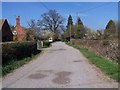
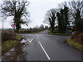
Hartlebury Barn
The view near Allscott, Shropshire.
Image: © Gordon Griffiths
Taken: 4 Aug 2020
0.10 miles
5
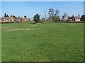
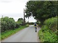
In the centre of Hartlebury
The crossroads in the centre of the collection of houses
Image: © Richard Law
Taken: 19 Feb 2011
0.13 miles
6
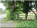
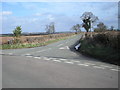
Hartlebury Approach
The view towards the cross roads in Shropshire.
Image: © Gordon Griffiths
Taken: 4 Aug 2020
0.18 miles
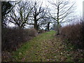
8
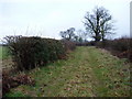
Rarely-used bridleway
The track back to the road (ie to the west of here) is well trafficked by farm vehicles, but from the footpath junction eastwards, it's much less used.
Image: © Richard Law
Taken: 19 Feb 2011
0.22 miles