IMAGES TAKEN NEAR TO
Crowgreaves, BRIDGNORTH, WV15 5LT
Introduction
This page details the photographs taken nearby to Crowgreaves, WV15 5LT by members of the Geograph project.
The Geograph project started in 2005 with the aim of publishing, organising and preserving representative images for every square kilometre of Great Britain, Ireland and the Isle of Man.

There are currently over 7.5m images from over14,400 individuals and you can help contribute to the project by visiting https://www.geograph.org.uk
Image Map
Images are licensed for reuse under creativecommons.org/licenses/by-sa/2.0
Notes
- Clicking on the map will re-center to the selected point.
- The higher the marker number, the further away the image location is from the centre of the postcode.
Image Listing (5 Images Found)
Images are licensed for reuse under creativecommons.org/licenses/by-sa/2.0
Image
Details
Distance
1
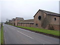
The Crowgreaves
A view of the side of the farm buildings, facing onto the B4176 Rabbit Run road. The round aperture in the nearest gable struck me as being the biggest owl hole I've ever seen.
Image: © Richard Law
Taken: 19 Feb 2011
0.02 miles
2
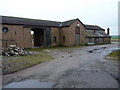
Barns at Crowgreaves
The large farm at Crowgreaves has a number of new(ish) barns, plus these much more picturesque older ones.
Image: © Richard Law
Taken: 19 Feb 2011
0.03 miles
3
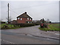
Cottages at Crowgreaves
A line of cottages opposite the farm at Crowgreaves, with postbox WV15 109 at the end of the lane.
Image: © Richard Law
Taken: 19 Feb 2011
0.07 miles
5
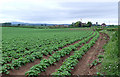
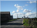
Potato Field, and Crowgreaves, Shropshire
The B4176, and Crowgreaves can be seen on the right skyline. The Wrekin is the distant hill on the left.
Image: © Roger Kidd
Taken: 17 May 2007
0.21 miles