IMAGES TAKEN NEAR TO
The Hobbins, BRIDGNORTH, WV15 5HW
Introduction
This page details the photographs taken nearby to WV15 5HW by members of the Geograph project.
The Geograph project started in 2005 with the aim of publishing, organising and preserving representative images for every square kilometre of Great Britain, Ireland and the Isle of Man.

There are currently over 7.5m images from over14,400 individuals and you can help contribute to the project by visiting https://www.geograph.org.uk
Image Map
Images are licensed for reuse under creativecommons.org/licenses/by-sa/2.0
Notes
- Clicking on the map will re-center to the selected point.
- The higher the marker number, the further away the image location is from the centre of the postcode.
Image Listing (7 Images Found)
Images are licensed for reuse under creativecommons.org/licenses/by-sa/2.0
Image
Details
Distance
2
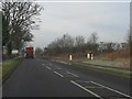
A454 Junction
The view of the road junction near Bridgnorth.
Image: © Gordon Griffiths
Taken: 4 Mar 2016
0.06 miles
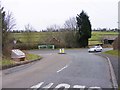
3
Path to the Ridge
The view of the footpath from the A454 near Bridgnorth.
Image: © Gordon Griffiths
Taken: 4 Mar 2016
0.11 miles
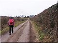
5
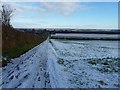
Track from Hermitage Hill coppice, in winter
Compare this scene with the early springtime view in Image
Image: © Richard Law
Taken: 5 Dec 2010
0.15 miles
6
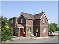
The Hobbins Post Office
The Hobbins is an isolated estate of former RAF married quarters at Stanmore near Bridgnorth.
Image: © John M
Taken: 5 May 2007
0.19 miles
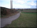
7

Footpath into the Stanmore Country Park
Leads from 'The Hobbins' into the former RAF training camp now an 80 hectare Country Park.
Image: © John M
Taken: 5 May 2007
0.21 miles