IMAGES TAKEN NEAR TO
Hermitage Heights, BRIDGNORTH, WV15 5EN
Introduction
This page details the photographs taken nearby to Hermitage Heights, WV15 5EN by members of the Geograph project.
The Geograph project started in 2005 with the aim of publishing, organising and preserving representative images for every square kilometre of Great Britain, Ireland and the Isle of Man.

There are currently over 7.5m images from over14,400 individuals and you can help contribute to the project by visiting https://www.geograph.org.uk
Image Map
Images are licensed for reuse under creativecommons.org/licenses/by-sa/2.0
Notes
- Clicking on the map will re-center to the selected point.
- The higher the marker number, the further away the image location is from the centre of the postcode.
Image Listing (195 Images Found)
Images are licensed for reuse under creativecommons.org/licenses/by-sa/2.0
Image
Details
Distance
2
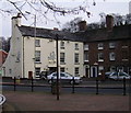
The Fox Inn (1), 46 Hospital Street
It describes itself as a traditional pub, but as it provides both food and accommodation, it is similar to a traditional inn. It recently underwent a change of management.
Image
Image
Image
Image: © P L Chadwick
Taken: 6 Jul 2010
0.06 miles
3
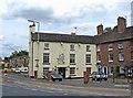
The Fox Inn (2), 46 Hospital Street
One of several pubs in the Low Town area of Bridgnorth. It has been in use as a pub or inn for at least 150 years. It appears in the 1861 census under its present name of The Fox Inn, but the address was at that time known as 34 St. John's Street.
More photos:- Image
Image: © P L Chadwick
Taken: 6 Jul 2010
0.06 miles
4
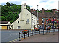
The Fox Inn (3) - sign, 46 Hospital Street
The sign is at the edge of the car park. At the time the photo was taken the pub was for sale, but by December 2010 it was under new management. The houses on the right are in Cann Hall Road.
More photos:- Image
Image: © P L Chadwick
Taken: 6 Jul 2010
0.06 miles
5
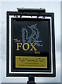
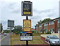
The Fox Inn (4) - sign close-up, 46 Hospital Street
This was the pub's sign in July 2010, at which time the pub was up for sale by its owner Enterprise Inns, a well-known pub chain. By December 2010, the pub was under new management, so it appears that Enterprise Inn were able to dispose of the pub. It is almost certain that the new owners would have replaced or repainted this sign.
More photos:- Image
Image: © P L Chadwick
Taken: 6 Jul 2010
0.06 miles
6
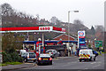
Petrol station in Bridgnorth, Shropshire
This is the A442 in Cann Hall Road, east of the River Severn.
Image: © Roger Kidd
Taken: 23 Nov 2018
0.06 miles
7
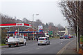
Cann Hall Road in Bridgnorth, Shropshire
This shows the A442 Cann Hall Road which changes to Hospital Street ahead. The road leads towards Kidderminster, and bypasses Bridgnorth High and Low Towns for traffic going to Shrewsbury.
Image: © Roger Kidd
Taken: 23 Nov 2018
0.07 miles
8
Wolverhampton Road near Bridgnorth in Shropshire
On a gloomy morning, this is the B4368 Wolverhampton Road starting the climb up the hill towards the main A454 road, seen from the A442 roundabout.
Image: © Roger Kidd
Taken: 23 Nov 2018
0.08 miles
9
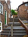
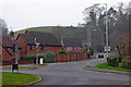
Bernards Hill Steps
The residential buildings adjacent to the steps are believed to date from the 18th and/or early 19th century.
Image: © P L Chadwick
Taken: 6 Jul 2010
0.09 miles
10
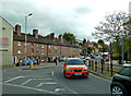
Cann Hall Road
Viewed at the junction with St Johns Street.
Image: © Mary and Angus Hogg
Taken: 14 Oct 2017
0.09 miles