IMAGES TAKEN NEAR TO
Lodge Lane, BRIDGNORTH, WV15 5BH
Introduction
This page details the photographs taken nearby to Lodge Lane, WV15 5BH by members of the Geograph project.
The Geograph project started in 2005 with the aim of publishing, organising and preserving representative images for every square kilometre of Great Britain, Ireland and the Isle of Man.

There are currently over 7.5m images from over14,400 individuals and you can help contribute to the project by visiting https://www.geograph.org.uk
Image Map
Images are licensed for reuse under creativecommons.org/licenses/by-sa/2.0
Notes
- Clicking on the map will re-center to the selected point.
- The higher the marker number, the further away the image location is from the centre of the postcode.
Image Listing (14 Images Found)
Images are licensed for reuse under creativecommons.org/licenses/by-sa/2.0
Image
Details
Distance
1
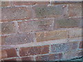
OS benchmark - Bridgnorth, 19 St Nicholas' Crescent
An OS cutmark on the bricks of no 19, St Nicholas' Crescent; originally levelled at 63.895m abov Ordnance Datum Newlyn.
Image: © Richard Law
Taken: 16 Mar 2014
0.09 miles
2
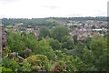
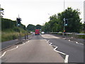
View over Low Town
From Castle Walk, Bridgnorth.
Image: © Richard Webb
Taken: 7 Aug 2017
0.09 miles
3
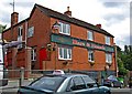
Hare & Hounds, 8 Bernards Hill
The pub describes itself as Bridgnorth's best kept secret, and it is certainly tucked away in a back street in the Low Town part of Bridgnorth. It has live music at times, and a beer garden with good views over the town. It used to be a M & B (Mitchells & Butler) pub. A traditional pub concentrating on selling drinks, the pub claims to be one of the oldest licensed premises in Bridgnorth. That is surprising, because the pub doesn't look that old. However there probably have been many alterations, and possibly the brick facade is hiding something much older.
Image: © P L Chadwick
Taken: 6 Jul 2010
0.12 miles
4
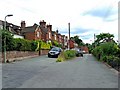
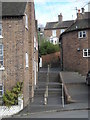
Bernards Hill
The last building on the left is the Hare & Hounds pub. Image
Image: © P L Chadwick
Taken: 6 Jul 2010
0.13 miles
5
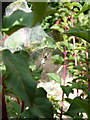
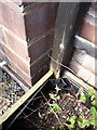
Nursery Web Spider in Bridgnorth
A female of the species Pisaura mirabilis, the common Nursery Web Spider, guarding the silk tent that she's erected over a nest of hatchlings. There were probably a couple of hundred young ones inside the tent, which affords them some protection until their first moult.
Image: © Richard Law
Taken: 9 Aug 2015
0.15 miles
6
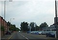
Ford car showroom, Bridgnorth
On Hospital Street, Low Town, Bridgnorth. Opposite is a short terrace of brick cottages.
Image: © David Smith
Taken: 23 Jul 2013
0.18 miles
9
OS benchmark - Bridgnorth, 51 Stourbridge Road
An OS cutmark on the frontage of no 51 Stourbridge Road; originally levelled at 61.112m above Ordnance Datum Newlyn.
Image: © Richard Law
Taken: 4 May 2014
0.19 miles
10
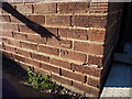
OS benchmark - Bridgnorth, 72 Lodge Lane
A well-defined OS cutmark in the bricks on the side wall of no 72 Lodge Lane, very helpfully pointed out by the owner, and originally levelled at 67m above Ordnance Datum Newlyn.
Image: © Richard Law
Taken: 16 Mar 2014
0.20 miles