IMAGES TAKEN NEAR TO
Wolverhampton Road, BRIDGNORTH, WV15 5AN
Introduction
This page details the photographs taken nearby to Wolverhampton Road, WV15 5AN by members of the Geograph project.
The Geograph project started in 2005 with the aim of publishing, organising and preserving representative images for every square kilometre of Great Britain, Ireland and the Isle of Man.

There are currently over 7.5m images from over14,400 individuals and you can help contribute to the project by visiting https://www.geograph.org.uk
Image Map
Images are licensed for reuse under creativecommons.org/licenses/by-sa/2.0
Notes
- Clicking on the map will re-center to the selected point.
- The higher the marker number, the further away the image location is from the centre of the postcode.
Image Listing (399 Images Found)
Images are licensed for reuse under creativecommons.org/licenses/by-sa/2.0
Image
Details
Distance
1
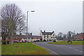
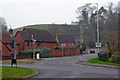
A442 roundabout in Bridgnorth, Shropshire
The A442 continues north towards Telford. Off to the right, the B4363 climbs the Wolverhampton Road hill towards the main A454. The Bandon Arms is on Mill Street.
Image: © Roger Kidd
Taken: 23 Nov 2018
0.02 miles
2
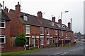
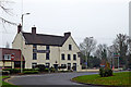
Housing in Mill Street in Bridgnorth
On the A442 north of the roundabout, are two terraces of houses belonging around a hundred years apart. This image shows the southern (and older) terrace, the design of which is replicated (approximately) the newer one. The older terrace has ten chimney stacks; the newer building has none.
Image: © Roger Kidd
Taken: 23 Nov 2018
0.02 miles
3
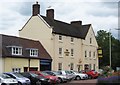
The Bandon Arms (1), 33 Mill Street, Bridgnorth, Shrops
This Marston's public house, on the edge of Low Town, has an interesting history. It is a Grade II listed building. The listing gives a date for the building of early 19th century. However the pub has a history going back to at least 1726 so maybe the date is wrong, or the building was rebuilt or relocated, as has happened to several pubs in the town. The present name was adopted in early Victorian times but previously it was the Hand & Bottle, and then the Bottle in Hand.
In 1726 it had its own malthouse and was home to a masonic lodge. It was one of the three pubs in Bridgnorth to have a cock fighting pit. The practice was legally banned in England and Wales in 1835.
Image
Image: © P L Chadwick
Taken: 6 Jul 2010
0.03 miles
4
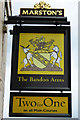
The Bandon Arms (2) - sign, 33 Mill Street, Bridgnorth, Shrops
Presumably named after a local family. There is also a Bandon Lane in Bridgnorth. The pub had other names long ago - see:- Image
Image: © P L Chadwick
Taken: 6 Jul 2010
0.03 miles
5
The Bandon Arms in Bridgnorth, Shropshire
This public house, which abuts terraced housing, is on Mill Street, which continues off the A442 roundabout towards Telford.
Image: © Roger Kidd
Taken: 23 Nov 2018
0.03 miles
6
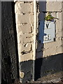
OS benchmark - Bridgnorth, The Bandon Arms
OS cutmark at the southern end of the frontage of the landmark pub The Bandon Arms; originally levelled at 33.703m above Ordnance Datum Newlyn.
Image: © Richard Law
Taken: 30 Dec 2013
0.03 miles
7
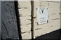
Bandon Arms Benchmark
The Ordnance Survey Benchmark cut into the wall of the Bandon Arms Public House. The OS records show that the Benchmark was last Levelled & verified in 1959. However, the historic maps show that the Benchmark was first cut in the 19th Century before 1882.
Image: © Anthony Rowley
Taken: 22 Jun 2022
0.03 miles
8
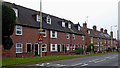
Housing by Mill Street in Bridgnorth
On the A 442 north of the roundabout, these two terraces of houses belong around a hundred years apart - the nearer terrace being designed to replicate (approximately) the older one. No chimneys were required on the new building.
Image: © Roger Kidd
Taken: 23 Nov 2018
0.03 miles
9
Wolverhampton Road near Bridgnorth in Shropshire
On a gloomy morning, this is the B4368 Wolverhampton Road starting the climb up the hill towards the main A454 road, seen from the A442 roundabout.
Image: © Roger Kidd
Taken: 23 Nov 2018
0.03 miles
10
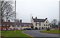
The Bandon Arms in Bridgnorth, Shropshire
This public house, which abuts terraced housing, is on Mill Street, which continues off the A442 roundabout towards Telford.
Image: © Roger Kidd
Taken: 23 Nov 2018
0.03 miles