IMAGES TAKEN NEAR TO
Upper Vauxhall, WOLVERHAMPTON, WV1 4SZ
Introduction
This page details the photographs taken nearby to Upper Vauxhall, WV1 4SZ by members of the Geograph project.
The Geograph project started in 2005 with the aim of publishing, organising and preserving representative images for every square kilometre of Great Britain, Ireland and the Isle of Man.

There are currently over 7.5m images from over14,400 individuals and you can help contribute to the project by visiting https://www.geograph.org.uk
Image Map
Images are licensed for reuse under creativecommons.org/licenses/by-sa/2.0
Notes
- Clicking on the map will re-center to the selected point.
- The higher the marker number, the further away the image location is from the centre of the postcode.
Image Listing (191 Images Found)
Images are licensed for reuse under creativecommons.org/licenses/by-sa/2.0
Image
Details
Distance
1
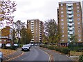
Vauxhall Flats
The view in Wolverhampton near the West Park.
Image: © Gordon Griffiths
Taken: 6 Nov 2016
0.02 miles
2
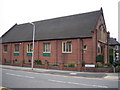
West Park Church
This church, on Connaught Road, is very close to West Park.
Image: © Angella Streluk
Taken: 22 Apr 2006
0.03 miles
3
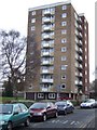
Council Housing - Connaught House
The 1960s Vauxhall Estate has three tower and three lower height blocks of flats. These replaced Victorian terrace housing between Tettenhall Road and West Park.
Image: © John M
Taken: 11 Dec 2010
0.04 miles
4
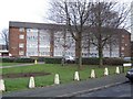
Council Housing - Upper Vauxhall
The 1960s Vauxhall Estate sandwiched between Tettenhall Road and West Park comprises medium and high rise blocks. The small estate replaced Victorian terraced properties. The estate lies within the Park Conservation Area.
Image: © John M
Taken: 11 Dec 2010
0.04 miles
5
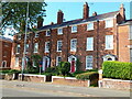
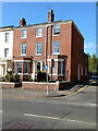
Cleveland Place, nos 26 - 32 Tettenhall Road, Wolverhampton
A terrace of 4 houses dating from the late 18th century, which were Grade II listed https://historicengland.org.uk/listing/the-list/list-entry/1201878 & https://britishlistedbuildings.co.uk/101201878-cleveland-place-park-ward in 1977. The internal staircase of no 32 is noted for its stick-baluster.
Image: © Richard Law
Taken: 20 May 2024
0.05 miles
6
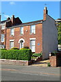
24 Tettenhall Road, Wolverhampton
Built in the 1830s, and described as having a staircase with stick balusters and a moulded ashlar fireplace in its 1992 Grade II listing https://historicengland.org.uk/listing/the-list/list-entry/1201877 & https://britishlistedbuildings.co.uk/101201877-24-tettenhall-road-park-ward
Image: © Richard Law
Taken: 20 May 2024
0.05 miles
7
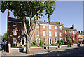
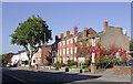
Georgian housing in Tettenhall Road, Wolverhampton
Cleveland Place.
This listed terrace of four houses is late 18th century, and typical of "restrained" Georgian style.
They were built at a time when Wolverhampton was expanding rapidly, but on the fashionable road to Tettenhall and at a safe distance from the factories. The narrow side street on the left is Upper Vauxhall, which leads towards West Park.
Image: © Roger D Kidd
Taken: 13 Oct 2010
0.05 miles
8
Georgian terraced housing, Wolverhampton
Cleveland Place.
This listed terrace of four houses in Tettenhall Road is late 18th century, and typical of "restrained" Georgian style.
They were built at a time when Wolverhampton was expanding rapidly, but on the fashionable road to Tettenhall and at a safe distance from the factories.
Information from http://www.localhistory.scit.wlv.ac.uk/listed/tettrd242632.htm .
Image: © Roger D Kidd
Taken: 13 Oct 2010
0.05 miles
9
Tettenhall Road, Wolverhampton
The narrow road passing between the Georgian terrace of four houses by the large tree is Upper Vauxhall, and leads towards West Park. That three storey terrace is Cleveland Place, a listed building from the late eighteenth century.
Image: © Roger D Kidd
Taken: 13 Oct 2010
0.05 miles
10
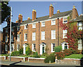
34 & 36 Tettenhall Road, Wolverhampton
Originally two houses, but now converted to one property, which were originally built in the late 18th century. The whole was Grade II listed https://historicengland.org.uk/listing/the-list/list-entry/1208414 & https://britishlistedbuildings.co.uk/101208414-34-and-36-tettenhall-road-park-ward in 1977.
Image: © Richard Law
Taken: 20 May 2024
0.05 miles