IMAGES TAKEN NEAR TO
Birch Street, WOLVERHAMPTON, WV1 4HY
Introduction
This page details the photographs taken nearby to Birch Street, WV1 4HY by members of the Geograph project.
The Geograph project started in 2005 with the aim of publishing, organising and preserving representative images for every square kilometre of Great Britain, Ireland and the Isle of Man.

There are currently over 7.5m images from over14,400 individuals and you can help contribute to the project by visiting https://www.geograph.org.uk
Image Map
Images are licensed for reuse under creativecommons.org/licenses/by-sa/2.0
Notes
- Clicking on the map will re-center to the selected point.
- The higher the marker number, the further away the image location is from the centre of the postcode.
Image Listing (780 Images Found)
Images are licensed for reuse under creativecommons.org/licenses/by-sa/2.0
Image
Details
Distance
1

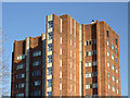
Carillion plc HQ, Wolverhampton
This thirteen floor tower housed the headquarters of the Tarmac (now Lafarge Tarmac) company until it separated off the new Carillion plc building operation in 1999. It is seen from the linear parkland separating the carriageways at Ring Road St Andrew's about 120 metres away. The building is 156 feet (47·54 metres) high.
Update 2023: In recent years the whole building has gradually been refurbished and transformed into studio apartments. The building is called simply, The Studios.
Image: © Roger D Kidd
Taken: 22 Nov 2013
0.01 miles
2
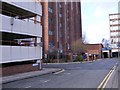
Carillion plc HQ (detail), Wolverhampton
This thirteen floor tower housed the headquarters of the Tarmac (now Lafarge Tarmac) company until it separated off the new Carillion plc building operation in 1999. The building is 156 feet (47·54 metres) high.
It is seen with telephoto assistance from the linear parkland between the carriageways at Ring Road St Andrew's about 75 metres away.
Update 2023: In recent years the whole building has gradually been refurbished and transformed into studio apartments. The building is called simply, The Studios.
Image: © Roger D Kidd
Taken: 22 Nov 2013
0.01 miles
3
Birch Street
The view towards the Ring Road in Wolverhampton.
Image: © Gordon Griffiths
Taken: 31 Jan 2013
0.02 miles
4
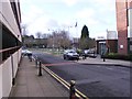
Clarence Road Junction
The junction with Birch Street in Wolverhampton.
Image: © Gordon Griffiths
Taken: 31 Jan 2013
0.02 miles
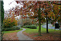
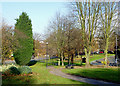
5
Parkland and Ring Road St Andrew's, Wolverhampton
From the Chapel Ash roundabout, clockwise to the crossroads at Waterloo Road, the two carriageways of the ring road are separated by a wide and attractively landscaped strip of public parkland. Mature trees and bushes grow in well tended grassy areas with seating.
Image: © Roger D Kidd
Taken: 22 Nov 2013
0.03 miles
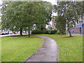
6
Wolverhampton Ring Road St Andrew's
This part of the ring road has an attractive landscaped area between the carriageways, complete with pathways and cast-iron (maybe) benches. Looking towards Waterloo Road. The anti-clockwise carriageway is on the right.
Image: © Roger D Kidd
Taken: 30 Oct 2009
0.03 miles
7
Wolverhampton Ring Road St Andrew's
This part of the ring road has a wide and attractive landscaped area between the carriageways, complete with pathways and cast-iron (maybe) benches. Traffic is approaching down the anticlockwise carriageway from the Waterloo Road crossroads.
Image: © Roger D Kidd
Taken: 30 Oct 2009
0.04 miles
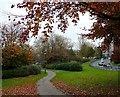
8
Ring Road Path
The path run along the central reservation of Ring Road St Andrews.
Image: © Gordon Griffiths
Taken: 22 Sep 2008
0.04 miles
9
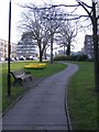
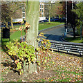
Ring Road Daffs
The path runs along the central reservation of Ring Road St Andrews, Wolverhampton.
Image: © Gordon Griffiths
Taken: 10 Apr 2010
0.04 miles
10
Parkland and Ring Road St Andrew's, Wolverhampton
From the Chapel Ash roundabout, clockwise to the crossroads at Waterloo Road, the two carriageways of the ring road are separated by a wide and attractively landscaped strip of public parkland. Mature trees and bushes grow in well tended grassy areas with seating.
Image: © Roger D Kidd
Taken: 22 Nov 2013
0.04 miles