IMAGES TAKEN NEAR TO
Walling Croft, BILSTON, WV14 9XR
Introduction
This page details the photographs taken nearby to Walling Croft, WV14 9XR by members of the Geograph project.
The Geograph project started in 2005 with the aim of publishing, organising and preserving representative images for every square kilometre of Great Britain, Ireland and the Isle of Man.

There are currently over 7.5m images from over14,400 individuals and you can help contribute to the project by visiting https://www.geograph.org.uk
Image Map
Images are licensed for reuse under creativecommons.org/licenses/by-sa/2.0
Notes
- Clicking on the map will re-center to the selected point.
- The higher the marker number, the further away the image location is from the centre of the postcode.
Image Listing (197 Images Found)
Images are licensed for reuse under creativecommons.org/licenses/by-sa/2.0
Image
Details
Distance
1
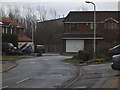
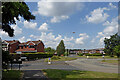
Walling Croft View
The view from Overfield Drive in Spring Vale, Wolverhampton.
Image: © Gordon Griffiths
Taken: 13 Dec 2013
0.02 miles
2
Hopyard Gardens
The view from Overfield Drive in Spring Vale, Wolverhampton.
Image: © Gordon Griffiths
Taken: 13 Dec 2013
0.03 miles
3
Walling Croft
The view from Overfield Drive in Spring Vale, Wolverhampton.
Image: © Gordon Griffiths
Taken: 24 May 2013
0.03 miles
4
Overfield Drive in Sedgemoor Park, Wolverhampton
Looking west-south-west along Overfield Drive, which goes round in a wide circle, ending up behind the camera! This private estate is attractively spacious, though "Overfield" is a romantic concept. The estate was built on the former Spring Vale Colliery ... ah! I see ... coalfield! ;-)
Image: © Roger Kidd
Taken: 20 Jul 2021
0.04 miles
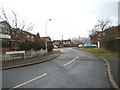
5
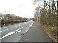
Black Country Route Scene
The view along the A463 dual carriageway in Bilston, Wolverhampton.
Image: © Gordon Griffiths
Taken: 13 Dec 2013
0.05 miles
6
Overfield Drive Island
The view from Overfield Drive in Spring Vale, Wolverhampton.
Image: © Gordon Griffiths
Taken: 13 Dec 2013
0.06 miles
7
Overfield Drive in Sedgmoor Park in Wolverhampton
Looking north-west from near the A463 Black Country Route. The Elisabeth Arms is off to the right.
The area was formerly covered with coal pits including the Spring Vale Colliery, which closed in 1890.
Image: © Roger Kidd
Taken: 20 Jul 2021
0.07 miles
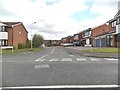
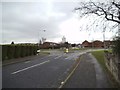
8
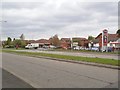
Overfield Drive in Spring Vale, Wolverhampton
The entrance to the Elisabeth Arms is to the right of the post box.
Image: © Roger D Kidd
Taken: 30 Apr 2014
0.07 miles
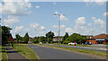
9
Sedgemoor Park. in Wolverhampton
The Sedgemoor Park housing estate was built on the site of the form Spring Vale Colliery.
Looking ahead (north-north-west) is Overfield Drive. Off to the left is Overfield Dive too, because it goes round in a circle!
Image: © Roger Kidd
Taken: 20 Jul 2021
0.07 miles
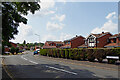
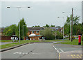
10
Shops and Pub
The Elisabeth Arms pub is named after the Blast Furnace at Stewart & Lloyds Steel Works in Spring Vale Bilston which closed in 1979.
Image: © Gordon Griffiths
Taken: 23 Apr 2014
0.07 miles