IMAGES TAKEN NEAR TO
Evergreen Close, BILSTON, WV14 9JQ
Introduction
This page details the photographs taken nearby to Evergreen Close, WV14 9JQ by members of the Geograph project.
The Geograph project started in 2005 with the aim of publishing, organising and preserving representative images for every square kilometre of Great Britain, Ireland and the Isle of Man.

There are currently over 7.5m images from over14,400 individuals and you can help contribute to the project by visiting https://www.geograph.org.uk
Image Map
Images are licensed for reuse under creativecommons.org/licenses/by-sa/2.0
Notes
- Clicking on the map will re-center to the selected point.
- The higher the marker number, the further away the image location is from the centre of the postcode.
Image Listing (116 Images Found)
Images are licensed for reuse under creativecommons.org/licenses/by-sa/2.0
Image
Details
Distance
1
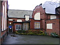
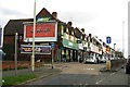
Dudley Archives
The local history service in the former Mount Pleasant Street School.
Image: © Gordon Griffiths
Taken: 20 Jan 2012
0.03 miles
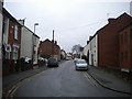
2
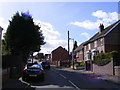
Ivyhouse Lane
The view up the lane in Roseville, Dudley.
Image: © Gordon Griffiths
Taken: 5 Oct 2017
0.05 miles
3
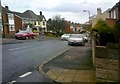
Hampton Street View
The view down Ivyhouse lane in Coseley, Dudley.
Image: © Gordon Griffiths
Taken: 21 Oct 2017
0.06 miles
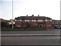
4
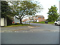
Breen Rydding Drive
The view from Ivyhouse Lane, Dudley.
Image: © Gordon Griffiths
Taken: 25 May 2013
0.07 miles

8
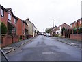
Ward Street
The view in Coseley, Dudley.
Image: © Gordon Griffiths
Taken: 23 Oct 2017
0.08 miles
9
Mount Pleasant Street, Roseville
Seen from the end of Bank Street.
Image: © Richard Vince
Taken: 23 Nov 2019
0.09 miles
10
New Road McDonald's
The view of fast food on the Birmingham New Road at Coseley.
Image: © Gordon Griffiths
Taken: 27 May 2013
0.09 miles