IMAGES TAKEN NEAR TO
Bilston Industrial Estate, Oxford Street, BILSTON, WV14 7EG
Introduction
This page details the photographs taken nearby to Bilston Industrial Estate, Oxford Street, WV14 7EG by members of the Geograph project.
The Geograph project started in 2005 with the aim of publishing, organising and preserving representative images for every square kilometre of Great Britain, Ireland and the Isle of Man.

There are currently over 7.5m images from over14,400 individuals and you can help contribute to the project by visiting https://www.geograph.org.uk
Image Map
Images are licensed for reuse under creativecommons.org/licenses/by-sa/2.0
Notes
- Clicking on the map will re-center to the selected point.
- The higher the marker number, the further away the image location is from the centre of the postcode.
Image Listing (35 Images Found)
Images are licensed for reuse under creativecommons.org/licenses/by-sa/2.0
Image
Details
Distance
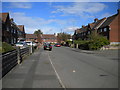
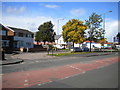
2
Watson Road, Moxley
Seen from Wilkinson Road.
Image: © Richard Vince
Taken: 22 Sep 2017
0.07 miles
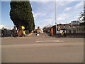
4
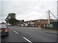
Bilston Industrial Estate
The view from the High Street (A41) in Moxley, Bilston.
Image: © Gordon Griffiths
Taken: 27 Sep 2016
0.07 miles
5
Oxford Street Car Wash
The view in to the Industrial Park alongside the A41 in Bilston.
Image: © Gordon Griffiths
Taken: 25 May 2014
0.08 miles
6
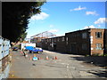
Hand car wash off Oxford Street, Bilston
Outside a derelict factory.
Image: © Richard Vince
Taken: 22 Sep 2017
0.10 miles
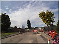
7
Oxford Street View
The view in the Industrial Area of the A41 in Bilston.
Image: © Gordon Griffiths
Taken: 25 May 2014
0.11 miles
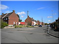
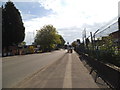
8
Former trolleybus turning circle, Moxley
This turning circle was used by Wolverhampton Corporation trolleybuses on route 47 (effectively a shortworking of the Darlaston route) from 29 October 1949, when the 47 was extended here, until motorbuses took over on 8 August 1965. It appears to have been altered in shape since then, presumably in connection with the construction of the houses visible on the left.
Image: © Richard Vince
Taken: 22 Sep 2017
0.13 miles
9

Oxford Street Post Box
The view in the Industrial Area of the A41 in Bilston.
Image: © Gordon Griffiths
Taken: 25 May 2014
0.14 miles
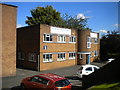
10
Harrowby Road
The view in to the new housing development alongside the A4098 in Bilston.
Image: © Gordon Griffiths
Taken: 25 May 2014
0.14 miles