IMAGES TAKEN NEAR TO
Udall Road, BILSTON, WV14 0SQ
Introduction
This page details the photographs taken nearby to Udall Road, WV14 0SQ by members of the Geograph project.
The Geograph project started in 2005 with the aim of publishing, organising and preserving representative images for every square kilometre of Great Britain, Ireland and the Isle of Man.

There are currently over 7.5m images from over14,400 individuals and you can help contribute to the project by visiting https://www.geograph.org.uk
Image Map
Images are licensed for reuse under creativecommons.org/licenses/by-sa/2.0
Notes
- Clicking on the map will re-center to the selected point.
- The higher the marker number, the further away the image location is from the centre of the postcode.
Image Listing (102 Images Found)
Images are licensed for reuse under creativecommons.org/licenses/by-sa/2.0
Image
Details
Distance
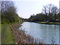
1
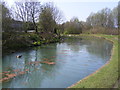
Canal Bend
The view of the bend on the Bradley Leg Canal near Dudley Street, Bilston.
Image: © Gordon Griffiths
Taken: 18 Apr 2010
0.03 miles
2
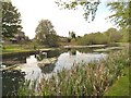
Canal Turn Around
The view of the winding hole on the Bradley Arm Canal in Bilston.
Image: © Gordon Griffiths
Taken: 29 Apr 2014
0.04 miles
3
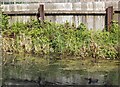
Coot Family
The view of the coots on the Bradley Leg Canal in Ladymoor, Bilston.
Image: © Gordon Griffiths
Taken: 3 May 2014
0.05 miles
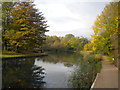
4
Canalside View
The view from Bradley Leg Canal towards Sedgley Beacon.
Image: © Gordon Griffiths
Taken: 8 Aug 2022
0.05 miles
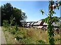
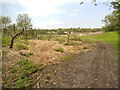
5
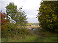
Footpath off Wednesbury Oak Loop, Coseley
A public footpath across some post industrial wasteland to Bilston.
Image: © Richard Vince
Taken: 20 Oct 2018
0.05 miles
6
Canal Scene
The view of the Bradley Leg Canal near Dudley Street, Bilston.
Image: © Gordon Griffiths
Taken: 18 Apr 2010
0.05 miles
7

New Development
The view of the new development of Urban Village Houses off Dudley Street in Bilston.
Image: © Gordon Griffiths
Taken: 17 Dec 2021
0.05 miles
8
Wednesbury Oak Loop, Coseley (1)
A verdant scene on the boundary between the Metropolitan Borough of Dudley and the City of Wolverhampton. South and west of here, the boundary follows the canal, with the canal itself being in Dudley, most of the way to Deepfields Junction.
Image: © Richard Vince
Taken: 20 Oct 2018
0.06 miles
9
Bradley Canal Bend
The view of the bend on the Bradley Arm Canal in Bilston.
Image: © Gordon Griffiths
Taken: 29 Apr 2014
0.06 miles
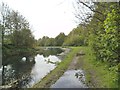
10
Woodland Path
The view of the path from the Bradley Arm Canal in Bilston.
Image: © Gordon Griffiths
Taken: 29 Apr 2014
0.06 miles