IMAGES TAKEN NEAR TO
Oxford Street, BILSTON, WV14 0PX
Introduction
This page details the photographs taken nearby to Oxford Street, WV14 0PX by members of the Geograph project.
The Geograph project started in 2005 with the aim of publishing, organising and preserving representative images for every square kilometre of Great Britain, Ireland and the Isle of Man.

There are currently over 7.5m images from over14,400 individuals and you can help contribute to the project by visiting https://www.geograph.org.uk
Image Map
Images are licensed for reuse under creativecommons.org/licenses/by-sa/2.0
Notes
- Clicking on the map will re-center to the selected point.
- The higher the marker number, the further away the image location is from the centre of the postcode.
Image Listing (143 Images Found)
Images are licensed for reuse under creativecommons.org/licenses/by-sa/2.0
Image
Details
Distance
1
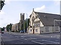
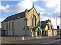
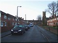
Oxford Street
The A41 passes through Bilston, by Holy Trinity Catholic and St Mary's C of E Churchs.
Image: © Gordon Griffiths
Taken: 7 Sep 2009
0.02 miles
2
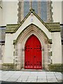
A smashing new paint job
This is the doorway of Bilston Catholic Church of The Holy Trinity, and in its previous guise is also visible (just in front of the car) in Image
Image: © Richard Law
Taken: 28 Jan 2009
0.02 miles
3
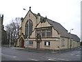
Bilston Catholic Church of The Holy Trinity
Image: © Richard Law
Taken: 28 Jan 2009
0.02 miles
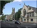
4
Holy Trinity RC Church, Bilston
In the foreground is the Holy Trinity Roman Catholic church. In the background is the Anglican Church of the Blessed St Mary.
Image: © Helen Steed
Taken: 26 Oct 2017
0.02 miles
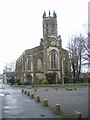
5
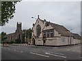
Bilston - Holy Trinity RC Church
On Oxford Street. For an alternative view, please see Image and for more information on this church, please see http://www.historywebsite.co.uk/listed/localist/BilstonHolyTrinity.htm .
Image: © Dave Bevis
Taken: 1 Nov 2014
0.02 miles
6
Roman Catholic Churches on the A41 in Bilston
This was the main road between Wolverhampton and West Bromwich until bypassed by a link to the Black Country Route.
Image: © John M
Taken: 23 Sep 2006
0.03 miles
7
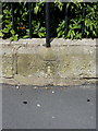
OS benchmark - Bilston, St Mary's Church
OS cutmark in the low wall surrounding Image Originally levelled at 132.573m abov Ordnance Datum Newlyn.
Image: © Richard Law
Taken: 1 Sep 2013
0.04 miles
8
Benchmark on St Mary's Church
This bench mark was established in 1844 during the First Primary Levelling of England & Wales, and was levelled with a height of 435.3500 feet [132.6947 metres] above mean sea level (Liverpool datum). It was included on the Manchester to Gloucester levelling line. The surveyor's description was "No. 284. Bolt in S. end of Bilston New Church ; 0.70 ft. above sill of door." (Public Abstract p.30). The 1887 map shows this mark on the south-east face, 2m from the south angle. It is not quite as close to the door as the description might imply, but can be found tucked into the internal angle of the wall, low down behind a shrub, looking rather the worse for wear.
Image: © Shantavira
Taken: 9 Nov 2014
0.04 miles
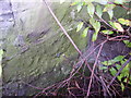
9
Tame Street, Bilston
The tower of St Mary's Church can be seen.
Image: © Geoff Pick
Taken: 5 Dec 2009
0.04 miles
10
Church of the Blessed St Mary, Bilston
Image: © Richard Law
Taken: 28 Jan 2009
0.05 miles