IMAGES TAKEN NEAR TO
Lawley Road, BILSTON, WV14 0NB
Introduction
This page details the photographs taken nearby to Lawley Road, WV14 0NB by members of the Geograph project.
The Geograph project started in 2005 with the aim of publishing, organising and preserving representative images for every square kilometre of Great Britain, Ireland and the Isle of Man.

There are currently over 7.5m images from over14,400 individuals and you can help contribute to the project by visiting https://www.geograph.org.uk
Image Map
Images are licensed for reuse under creativecommons.org/licenses/by-sa/2.0
Notes
- Clicking on the map will re-center to the selected point.
- The higher the marker number, the further away the image location is from the centre of the postcode.
Image Listing (146 Images Found)
Images are licensed for reuse under creativecommons.org/licenses/by-sa/2.0
Image
Details
Distance
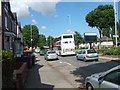
1
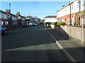
Lawley Road
The view down the Bilston Road.
Image: © Gordon Griffiths
Taken: 13 Nov 2010
0.00 miles
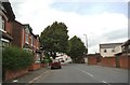
2
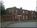
Council housing in Lawley Road
Bilston Urban District Council built a large number of houses in the 1920s and 1930s. This design is probably from the 1930s and was used at various locations in the town.
Image: © John M
Taken: 19 Sep 2009
0.02 miles
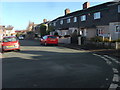
3
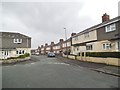
Prestfield Street View
The view down Lawley Road in Bilston.
Image: © Gordon Griffiths
Taken: 22 Apr 2014
0.04 miles
4
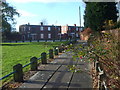
Freezeland Walk
The pathway from Wolverhampton Street to Lawley Road Bilston.
Image: © Gordon Griffiths
Taken: 13 Nov 2010
0.05 miles
5
Island View
The view on Wellington Road, Bilston.
Image: © Gordon Griffiths
Taken: 10 Aug 2012
0.06 miles
6
Hall Park Street
The view in Ettingshall, Bilston.
Image: © Gordon Griffiths
Taken: 20 Aug 2013
0.06 miles
7
Freezeland Street
The view in the Bilston Street.
Image: © Gordon Griffiths
Taken: 13 Nov 2010
0.07 miles
8
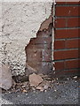
OS benchmark - no 194, Wellington Road
A cutmark in the boundary wall (facing the footpath) of no 194 Wellington Road. This one would be lost but for the fact that the rendering is in need of repair; I only had to move one loose piece of render to expose the BM again. How long before it's covered again? Originally levelled at a height of 136.4834m, 447'9" above Ordnance Datum Newlyn.
Image: © Richard Law
Taken: 2 Aug 2013
0.08 miles
9
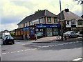
Hadley Road Shop
The news and wine shop on the corner of Wellington Road, Bilston.
Image: © Gordon Griffiths
Taken: 9 Jun 2009
0.08 miles
10
Lawley Road Path
The pathway from Wolverhampton Street to Lawley Road Bilston.
Image: © Gordon Griffiths
Taken: 10 Aug 2012
0.08 miles