IMAGES TAKEN NEAR TO
Norman Davies Gardens, BILSTON, WV14 0BD
Introduction
This page details the photographs taken nearby to Norman Davies Gardens, WV14 0BD by members of the Geograph project.
The Geograph project started in 2005 with the aim of publishing, organising and preserving representative images for every square kilometre of Great Britain, Ireland and the Isle of Man.

There are currently over 7.5m images from over14,400 individuals and you can help contribute to the project by visiting https://www.geograph.org.uk
Image Map
Images are licensed for reuse under creativecommons.org/licenses/by-sa/2.0
Notes
- Clicking on the map will re-center to the selected point.
- The higher the marker number, the further away the image location is from the centre of the postcode.
Image Listing (103 Images Found)
Images are licensed for reuse under creativecommons.org/licenses/by-sa/2.0
Image
Details
Distance
1
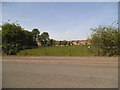
Highfields Road Field
The view of the former school playing field in Ladymoor, Bilston.
Image: © Gordon Griffiths
Taken: 3 May 2014
0.03 miles
2
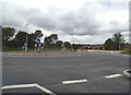
New Roundabout
The view in Highfields Road, Ladymoor, Bilston. The island is for the new urban village.
Image: © Gordon Griffiths
Taken: 4 Aug 2016
0.04 miles
3
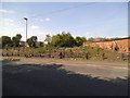
Highfields Road Scene
The view of wasteland off the road in Ladymoor, Bilston.
Image: © Gordon Griffiths
Taken: 3 May 2014
0.04 miles
4
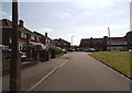
Broadmoor Road Corner
The view alongside the green in Ladymoor, Bilston.
Image: © Gordon Griffiths
Taken: 3 May 2014
0.05 miles
5
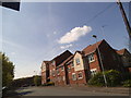
Highfields Road Flats
The view of the flats built on the former Broad Lanes School in Ladymoor, Bilston.
Image: © Gordon Griffiths
Taken: 3 May 2014
0.06 miles
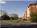
6

Old School Court, Ladymoor
A sign of the times - this is a recent development on the site of a former Victorian primary school. At least the name recalls the previous use of the area.
Image: © Richard Law
Taken: 9 Jan 2009
0.06 miles
7
Highfields Road View
The view up Broad Lanes in Ladymoor, Bilston.
Image: © Gordon Griffiths
Taken: 3 May 2014
0.07 miles
8
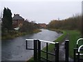
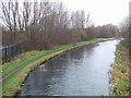
A wet day on the Wednesbury Oak Loop
The Wednesbury Oak Loop was the original line of the Birmingham to Wolverhampton Canal before the construction of the Coseley Tunnel by Thomas Telford in 1837. It is now incomplete and terminates near Bradley: the southern section has been filled in.
Image: © John M
Taken: 10 Dec 2006
0.08 miles
9
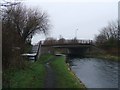
Highfields Bridge
This prestressed concrete beam bridge carries Highfields Road over the Wednesbury Oak Loop.
Image: © John M
Taken: 10 Dec 2006
0.08 miles
10
Staffordshire Bull Terrier and owner out in the rain
This pair were out taking a walk along the towpath of the Wednesbury Oak Loop.
Image: © John M
Taken: 10 Dec 2006
0.08 miles