IMAGES TAKEN NEAR TO
Abney Close, BILSTON, WV14 0AN
Introduction
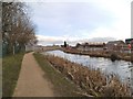
This page details the photographs taken nearby to Abney Close, WV14 0AN by members of the Geograph project.
The Geograph project started in 2005 with the aim of publishing, organising and preserving representative images for every square kilometre of Great Britain, Ireland and the Isle of Man.

There are currently over 7.5m images from over14,400 individuals and you can help contribute to the project by visiting https://www.geograph.org.uk
Image Map
Images are licensed for reuse under creativecommons.org/licenses/by-sa/2.0
Notes
- Clicking on the map will re-center to the selected point.
- The higher the marker number, the further away the image location is from the centre of the postcode.
Image Listing (108 Images Found)
Images are licensed for reuse under creativecommons.org/licenses/by-sa/2.0
Image
Details
Distance
1
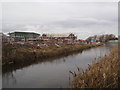
Canal Housing
The view from Salop Street in Bilston with a new housing development on the left on the former Sankey Works site alongside the Bradley Leg Canal.
Image: © Gordon Griffiths
Taken: 22 Feb 2014
0.01 miles
2
Bridge View
The view of the Salop Street bridge in Bilston, on the right is the former Sankey Works site alongside the Bradley Leg Canal.
Image: © Gordon Griffiths
Taken: 22 Feb 2014
0.02 miles
3
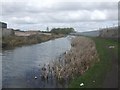
Bradley Arm Canal
The canal leads from the 'New Main Line' to the British Waterways workshops. Once part of Brindley's 'Old Main Line' and latterly the 'Wednesbury Oak Loop'.
Image: © John M
Taken: 4 Apr 2009
0.02 miles
4
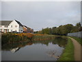
Wednesbury Oak Loop, Bradley (2)
North west of Pothouse Bridge, showing some of the housing development that has taken place on formerly industrial land in this area in recent years.
Image: © Richard Vince
Taken: 20 Oct 2018
0.03 miles
5
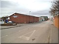
Greenway Road
The view of a Industrial Area of Bradley, Bilston.
Image: © Gordon Griffiths
Taken: 22 Feb 2014
0.04 miles
6
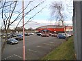
Latifs Store
The view of the Discount Store in Bilston alongside the Bradley Leg Canal.
Image: © Gordon Griffiths
Taken: 22 Feb 2014
0.05 miles
7
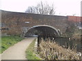
Pot House Bridge
The view of the bridge carrying Salop Street over the Bradley Leg Canal in Bilston.
Image: © Gordon Griffiths
Taken: 22 Feb 2014
0.05 miles
8
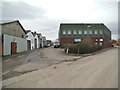
Hatton Street
The view of an industrial area of Bradley, Bilston.
Image: © Gordon Griffiths
Taken: 22 Feb 2014
0.05 miles
9
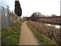
Towpath Scene
The view in Bilston with a new housing development on the right on the former Sankey Works site alongside the Bradley Leg Canal.
Image: © Gordon Griffiths
Taken: 22 Feb 2014
0.05 miles
10

Loxdale Sidings View
The view down Loxdale Street from Loxdale Sidings in Bilston next to the Bradley Leg Canal.
Image: © Gordon Griffiths
Taken: 22 Feb 2014
0.05 miles