IMAGES TAKEN NEAR TO
WV1 3YZ
Introduction
This page details the photographs taken nearby to WV1 3YZ by members of the Geograph project.
The Geograph project started in 2005 with the aim of publishing, organising and preserving representative images for every square kilometre of Great Britain, Ireland and the Isle of Man.

There are currently over 7.5m images from over14,400 individuals and you can help contribute to the project by visiting https://www.geograph.org.uk
Image Map
Images are licensed for reuse under creativecommons.org/licenses/by-sa/2.0
Notes
- Clicking on the map will re-center to the selected point.
- The higher the marker number, the further away the image location is from the centre of the postcode.
Image Listing (1240 Images Found)
Images are licensed for reuse under creativecommons.org/licenses/by-sa/2.0
Image
Details
Distance
1
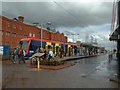
Sainsbury's View
The view alongside the supermarket in St George's Parade Wolverhampton.
Image: © Gordon Griffiths
Taken: 5 Nov 2010
0.01 miles
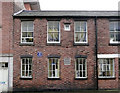
2
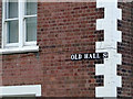
Old Hall Street sign, Wolverhampton
When the old buildings in this street were restored in the early 2000s, the original street sign was kept. Old Hall Street has long been at the hub of the Wolverhampton Adult Education Service.
Image: © Roger D Kidd
Taken: 25 Jan 2010
0.01 miles
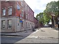
3
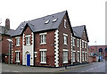
Corner of Old Hall Street, Wolverhampton
This is at the junction with George's Parade, named after the adjacent former church (now assimilated into Sainsbury's store). Image]
During the smartening-up of Old Hall Street in the early 2000s, many of the old buildings were refurbished and are used for business purposes. Much of the street is occupied by the Wolverhampton Adult Education Service and includes their cafe, also open to the public.
Image: © Roger D Kidd
Taken: 25 Jan 2010
0.01 miles
4
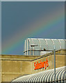
Rainbow over Sainsbury's, Wolverhampton
Telephoto assisted image.
In St George's Parade, the rainbow was seen over Sainsbury's on the day when Tesco announced a 12% drop in profits, and Sainsbury's announced a slight rise! So where is the pot of gold?
See also: Image]
Image: © Roger D Kidd
Taken: 3 Oct 2012
0.02 miles
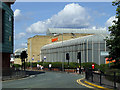
5
Wolverhampton.
The Wolverhampton terminus of the Midlands Metro.
Image: © David Stowell
Taken: 21 Apr 2000
0.02 miles
6
Old Hall Street
The view in Wolverhampton City.
Image: © Gordon Griffiths
Taken: 31 May 2020
0.02 miles
7
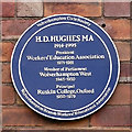
Plaque celebrating H D Hughes, Wolverhampton
This plaque can be seen on the wall of the restored building housing the cafe of the Adult Education Service in Old Hall Street. H D Hughes was heavily involved in Adult Education in the city. He had the "distinction" of losing his (Labour) parliamentary seat in 1950, very narrowly, to a certain Tory called - Enoch Powell.
Image: © Roger D Kidd
Taken: 18 Jan 2010
0.02 miles
8
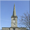
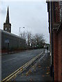
The Spire, St. George's Church, Wolverhampton (Sainsbury's)
Built 1828-1830, brick, encased in Tixall stone. http://www.tixall-ingestre-andrews.me.uk/tixall/txlqrry.html
Image: © Roger Kidd
Taken: 5 Apr 2007
0.02 miles
9
Restored building, in Old Hall Street, Wolverhampton
This restored building now houses the kitchen area of the Adult Education Service cafe. Image]
The blue plaque celebrates the work of H D Hughes, MA. Among other posts, he was president of the Workers Education Association, and was Member of Parliament for Wolverhampton West.
Image]
Image: © Roger D Kidd
Taken: 18 Jan 2010
0.02 miles
10
Sainsbury's, Wolverhampton
This is the monstrosity that Sainsbury's were allowed to attach to the Victorian architecture of St George's Church when they converted it to a supermarket in 1988. Image]
Image: © Roger D Kidd
Taken: 22 Aug 2009
0.02 miles