IMAGES TAKEN NEAR TO
Ambrose Close, WILLENHALL, WV13 3DQ
Introduction
This page details the photographs taken nearby to Ambrose Close, WV13 3DQ by members of the Geograph project.
The Geograph project started in 2005 with the aim of publishing, organising and preserving representative images for every square kilometre of Great Britain, Ireland and the Isle of Man.

There are currently over 7.5m images from over14,400 individuals and you can help contribute to the project by visiting https://www.geograph.org.uk
Image Map
Images are licensed for reuse under creativecommons.org/licenses/by-sa/2.0
Notes
- Clicking on the map will re-center to the selected point.
- The higher the marker number, the further away the image location is from the centre of the postcode.
Image Listing (10 Images Found)
Images are licensed for reuse under creativecommons.org/licenses/by-sa/2.0
Image
Details
Distance
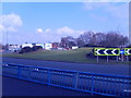
3
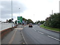
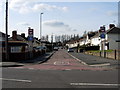
Willenhall Road (A454)
Approaching roundabout.
Image: © JThomas
Taken: 5 Oct 2013
0.18 miles
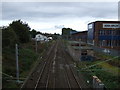
5
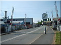
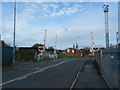
Level Crossing
The crossing on Noose Lane.
Image: © Gordon Griffiths
Taken: 28 Apr 2007
0.19 miles
6
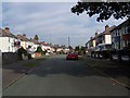
Park Avenue, Willenhall
There is an entrance to the Memorial Park near to the end of the avenue. This was the site of what must have been one of the last Gas Lights in the area (1960s).
Image: © Tim Marshall
Taken: 2 Mar 2010
0.21 miles
7
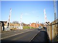
Noose Lane level crossing
This is the opposite view to the one in Image
Image: © Richard Law
Taken: 20 Jan 2009
0.22 miles
9
Keyway Island Portobello
The A454 bypasses Willenhall on its way to the M6, viewed from the New Street junction.
Image: © Gordon Griffiths
Taken: 5 Mar 2009
0.22 miles
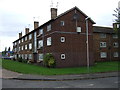
10
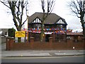
The Shri Guru Ravidass Temple
Located on Somerford Place, Willenhall.
Image: © Richard Law
Taken: 13 Mar 2009
0.23 miles