IMAGES TAKEN NEAR TO
Beech Road, WILLENHALL, WV13 3DD
Introduction
This page details the photographs taken nearby to Beech Road, WV13 3DD by members of the Geograph project.
The Geograph project started in 2005 with the aim of publishing, organising and preserving representative images for every square kilometre of Great Britain, Ireland and the Isle of Man.

There are currently over 7.5m images from over14,400 individuals and you can help contribute to the project by visiting https://www.geograph.org.uk
Image Map
Images are licensed for reuse under creativecommons.org/licenses/by-sa/2.0
Notes
- Clicking on the map will re-center to the selected point.
- The higher the marker number, the further away the image location is from the centre of the postcode.
Image Listing (11 Images Found)
Images are licensed for reuse under creativecommons.org/licenses/by-sa/2.0
Image
Details
Distance

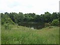
3
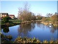
Pool at Fibbersley Nature Reserve
This one looks a little less marshy than some of its neighbours.
Image: © Richard Law
Taken: 20 Jan 2009
0.13 miles
4
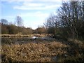
Marshy pool at Fibbersley Nature Reserve
One of the pools that form the Nature Reserve.
Image: © Richard Law
Taken: 20 Jan 2009
0.15 miles
5
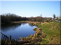
Pool at Fibbersley Nature Reserve
The road (just visible on the right) that runs alongside the nature reserve is called Watery Lane, presumably on account of the marshy pools here at the eastern end.
Image: © Richard Law
Taken: 20 Jan 2009
0.17 miles
6
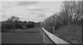
Track bed of the closed Walsall - Wolverhampton line looking towards Noose Lane and Wednesfield.
Track bed of the closed Walsall - Wolverhampton line looking towards Noose Land Bridge and Wednesfield. This is an up to date reproduction of my submission http://www.geograph.org.uk/photo/1584224 taken in 1978.
Image: © Tim Marshall
Taken: 2 Mar 2010
0.20 miles
7
Track bed of the closed Walsall - Wolverhampton line looking towards Willenhall.
Track bed of the closed Walsall - Wolverhampton line looking towards Willenhall Stafford Street Station, Willenhall park off to the right and this is now part of the park. 1978.
Image: © Tim Marshall
Taken: 17 Oct 1978
0.22 miles
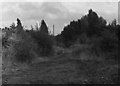
8
Pool - Fibbersley Local Nature Reserve
A legacy of deep coal mining and clay pits has left a scarred landscape that has reverted to nature.
Image: © John M
Taken: 7 Jun 2008
0.22 miles
9
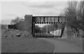
Track Bed, closed Walsall - Wolverhampton Line at Willenhall - 2010.
Track bed of closed Walsall - Wolverhampton line just short of the "Iron Bridge", looking towards Noose Lane and Wednesfield,2010. This is an up to date shot of my previous submission http://www.geograph.org.uk/photo/1584212. Things have certainly changed in the last 32 years.
Image: © Tim Marshall
Taken: 2 Mar 2010
0.22 miles
10
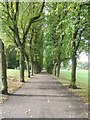
Avenue of trees
A pathway down towards the fishing pool in the Memorial Park in Willenhall.
Image: © John M
Taken: 30 Sep 2006
0.23 miles