IMAGES TAKEN NEAR TO
Wakes Close, WILLENHALL, WV13 2HB
Introduction
This page details the photographs taken nearby to Wakes Close, WV13 2HB by members of the Geograph project.
The Geograph project started in 2005 with the aim of publishing, organising and preserving representative images for every square kilometre of Great Britain, Ireland and the Isle of Man.

There are currently over 7.5m images from over14,400 individuals and you can help contribute to the project by visiting https://www.geograph.org.uk
Image Map
Images are licensed for reuse under creativecommons.org/licenses/by-sa/2.0
Notes
- Clicking on the map will re-center to the selected point.
- The higher the marker number, the further away the image location is from the centre of the postcode.
Image Listing (46 Images Found)
Images are licensed for reuse under creativecommons.org/licenses/by-sa/2.0
Image
Details
Distance
1
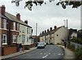
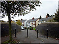
Gipsy Lane in Willenhall, Walsall
A narrow "one way" section north of the railway cutting.
Image: © Roger D Kidd
Taken: 18 Oct 2013
0.07 miles
2
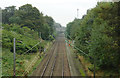
Railway line in Willenhall, Walsall
This image from the north end of William Harper Road shows the line between Wolverhampton and Walsall, looking towards Walsall and the Bilston Lane Bridge.
Image: © Roger D Kidd
Taken: 18 Oct 2013
0.07 miles
3
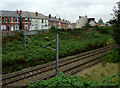
Railway in a cutting, Willenhall, Walsall
This image from the north end of William Harper Road shows the line between Wolverhampton and Walsall and, looking across to terraced housing in Gipsy Lane.
Image: © Roger D Kidd
Taken: 18 Oct 2013
0.07 miles
4
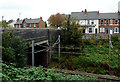
Railway and bridge in Willenhall, Walsall
This image from the north end of William Harper Road shows the line in its cutting between Walsall and Wolverhampton, looking across to housing in Gipsy Lane. The narrow bridge is no longer open to traffic, but remains as a footpath/cycleway.
Image: © Roger D Kidd
Taken: 18 Oct 2013
0.08 miles
5

St. Giles, Willenhall
St. Giles church was rebuilt in 1867 to replace a brick built church which, in turn, had replaced a half timbered medieval church in 1750.
Image: © Jurek and Trish Sienkiewicz
Taken: 30 May 2007
0.09 miles
6
Footpath across the railway in Willenhall, Walsall
The railway line between Wolverhampton and Walsall is in a cutting as it passes through Willenhall. This path uses the bridge crossing it between Gipsy Lane and William Harper Road (seen here). Can a local person let me know when the route was closed to motor traffic please?
Image: © Roger D Kidd
Taken: 18 Oct 2013
0.09 miles
7
Gipsy Lane in Willenhall, Walsall
A narrow "one way" section north of the railway cutting.
Image: © Roger D Kidd
Taken: 18 Oct 2013
0.10 miles
8
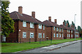
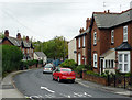
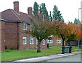
Housing in William Harper Road, Willenhall, Walsall
Image: © Roger D Kidd
Taken: 18 Oct 2013
0.10 miles
9
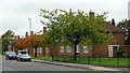
Housing in William Harper Road, Willenhall, Walsall
Image: © Roger D Kidd
Taken: 18 Oct 2013
0.11 miles
10
Housing in William Harper Road, Willenhall, Walsall
Image: © Roger D Kidd
Taken: 18 Oct 2013
0.11 miles