IMAGES TAKEN NEAR TO
Willenhall Road, WOLVERHAMPTON, WV1 2JW
Introduction
This page details the photographs taken nearby to Willenhall Road, WV1 2JW by members of the Geograph project.
The Geograph project started in 2005 with the aim of publishing, organising and preserving representative images for every square kilometre of Great Britain, Ireland and the Isle of Man.

There are currently over 7.5m images from over14,400 individuals and you can help contribute to the project by visiting https://www.geograph.org.uk
Image Map
Images are licensed for reuse under creativecommons.org/licenses/by-sa/2.0
Notes
- Clicking on the map will re-center to the selected point.
- The higher the marker number, the further away the image location is from the centre of the postcode.
Image Listing (29 Images Found)
Images are licensed for reuse under creativecommons.org/licenses/by-sa/2.0
Image
Details
Distance
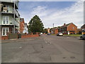
1
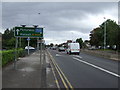
Willenhall Road View
The view along the Willenhall Road A454 in Wolverhampton.
Image: © Gordon Griffiths
Taken: 29 Jul 2022
0.04 miles
2
Under lock and key on the Willenhall Road
Willenhall and Wolverhampton were home to the British lockmaking industry, Chubb, Yale, etc. Sadly much of this has been sold off to foreign companies and the products are manufactured in China.
Image: © John M
Taken: 21 Apr 2013
0.07 miles
3
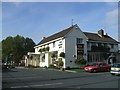
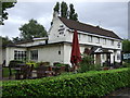
The Merry Boys
The principal features of the junctions on the Willenhall Road are pubs, churches and traffic lights. This pub is at the junction with Dean's Road
Image: © John M
Taken: 29 Oct 2006
0.08 miles
4
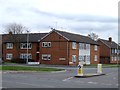
Council Housing - Hurstbourne Crescent
Early 1950s properties on the East Park Estate.
Image: © John M
Taken: 21 Apr 2013
0.08 miles
5
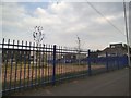
School Scene
The view of St Matthias School, a new building on the site of the former Deansfield High School off Dean's Road, Wolverhampton.
Image: © Gordon Griffiths
Taken: 18 Aug 2016
0.09 miles
7
The Merry Boys
The view of the Pub on Dean's Road, Wolverhampton.
Image: © Gordon Griffiths
Taken: 18 Aug 2017
0.10 miles
8
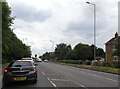
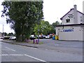
Mayfield Road View
The view up Hurstbourne Crescent in East Park, Wolverhampton.
Image: © Gordon Griffiths
Taken: 26 May 2014
0.11 miles
9
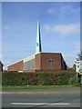
St Joseph's RC Church
The church is at the junction of Stow Heath Lane and Willenhall Road. This view of the church shows the prominent bright green spire. The rest of the sloping roof and that of the vicarage is similarly coloured.
Image: © John M
Taken: 29 Oct 2006
0.12 miles