IMAGES TAKEN NEAR TO
Friesland Drive, WOLVERHAMPTON, WV1 2AN
Introduction
This page details the photographs taken nearby to Friesland Drive, WV1 2AN by members of the Geograph project.
The Geograph project started in 2005 with the aim of publishing, organising and preserving representative images for every square kilometre of Great Britain, Ireland and the Isle of Man.

There are currently over 7.5m images from over14,400 individuals and you can help contribute to the project by visiting https://www.geograph.org.uk
Image Map
Images are licensed for reuse under creativecommons.org/licenses/by-sa/2.0
Notes
- Clicking on the map will re-center to the selected point.
- The higher the marker number, the further away the image location is from the centre of the postcode.
Image Listing (36 Images Found)
Images are licensed for reuse under creativecommons.org/licenses/by-sa/2.0
Image
Details
Distance
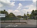
1
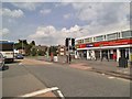
One Stop Store
The view in Deans Road, Wednesfield.
Image: © Gordon Griffiths
Taken: 19 May 2014
0.03 miles
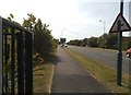
2
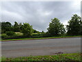
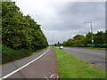
View to Solar Farm
The view over the A4124 in Wednesfield, Wolverhampton.
Image: © Gordon Griffiths
Taken: 13 Aug 2023
0.14 miles
3
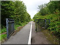
Path Gates
The view towards Wednesfield Way (A4124) in Wednesfield, Wolverhampton.
Image: © Gordon Griffiths
Taken: 13 Aug 2023
0.19 miles
4
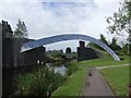
Wyrley & Essington Canal - Demolished Railway Bridge
The line to Wednesfield and Willenhall was closed in the 1960s. The steel arch appeared when the Wednesfield Bypass was built in the late 1990s.
Image: © John M
Taken: 10 Aug 2008
0.20 miles
5
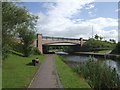
Wyrley & Essington Canal - Heath Town Bridge
Neat modern canal bridge carrying Wednesfield Way.
Image: © John M
Taken: 10 Aug 2008
0.20 miles
6
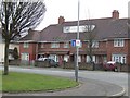
Council Housing - Ashbourne Road
Pre-war development around 1937 with characteristic concrete block wall to frontage. The properties back on to the railway.
Image: © John M
Taken: 12 Mar 2011
0.21 miles
7
Council Housing - Ashbourne Road
Pre-war housing dating from 1937 with the characteristic concrete block walls to frontages also found on the Scotlands and Marsh Lane Estates.
Image: © John M
Taken: 12 Mar 2011
0.21 miles
8
Wednesfield Way View
The view of the A4124 in Wednesfield, Wolverhampton
Image: © Gordon Griffiths
Taken: 16 Aug 2016
0.21 miles
9
Wednesfield Way
The view of the A4124 in Wednesfield, Wolverhampton.
Image: © Gordon Griffiths
Taken: 13 Aug 2023
0.21 miles
10
Canal Bridge View
The view from the Deans Road bridge down the Wyrley and Essington canal at Wednesfield.
Image: © Gordon Griffiths
Taken: 19 May 2014
0.21 miles