IMAGES TAKEN NEAR TO
Woodside Way, WILLENHALL, WV12 5NN
Introduction
This page details the photographs taken nearby to Woodside Way, WV12 5NN by members of the Geograph project.
The Geograph project started in 2005 with the aim of publishing, organising and preserving representative images for every square kilometre of Great Britain, Ireland and the Isle of Man.

There are currently over 7.5m images from over14,400 individuals and you can help contribute to the project by visiting https://www.geograph.org.uk
Image Map
Images are licensed for reuse under creativecommons.org/licenses/by-sa/2.0
Notes
- Clicking on the map will re-center to the selected point.
- The higher the marker number, the further away the image location is from the centre of the postcode.
Image Listing (42 Images Found)
Images are licensed for reuse under creativecommons.org/licenses/by-sa/2.0
Image
Details
Distance
1
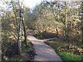
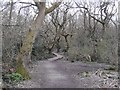
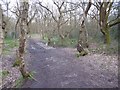
Footpaths in the Rough Wood Local Nature Reserve
The nature reserve is in an area worked for clay and coal since the 1700s.
Image: © John M
Taken: 17 Nov 2007
0.10 miles
3
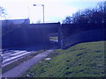
M6 Bridge
The M6 passes over Willenhall Road near Walsall.
Image: © Gordon Griffiths
Taken: 5 Mar 2009
0.11 miles
4
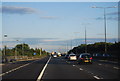
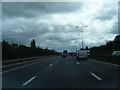
Northbound M6 near Bloxwich
In an example of Active Traffic Management on the congested M6 motorway, the matrix sign ahead invites drivers to use the hard shoulder as an extra running lane.
Active Traffic Management (ATM) is a system used on motorways where the gantry signs are computer-controlled to set a variable speed limit, open the hard shoulder as a running lane and limit the volume of traffic entering at junctions, with the aim of improving the flow of traffic (see http://www.cbrd.co.uk/indepth/atm/ for more detailed information about the Active Traffic Management system).
Image: © David Dixon
Taken: 21 Dec 2012
0.11 miles
5

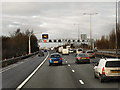
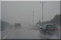
Smart motorway in operation
Why is only one of the red circles working? The one mile sign for Junction 10 can be seen further ahead.
Image: © Bill Boaden
Taken: 27 Dec 2016
0.13 miles
6
Rough Wood
The go to place for gnarly trees, a long established woodland on small spoil heaps with many marshy depressions. Over the years the path network has improved, not so muddy now.
Image: © Richard Webb
Taken: 13 Apr 2016
0.13 miles
8
Bloxwich : M6 Motorway
The M6 motorway heading between Junction 10A and Junction 10 (Walsall Interchange).
Image: © Lewis Clarke
Taken: 27 Sep 2019
0.14 miles
9
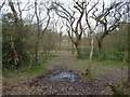
Rough Wood
A small but very interesting oak and thorn wood on very old mining terrain (it is shown as woodland on 19th century maps). There are numerous marshy depressions and dense thorn patches. Never quiet in here though as the M6 is next door.
Image: © Richard Webb
Taken: 13 Apr 2016
0.15 miles
10
Rough Wood
Oak woods on old mining ground, there are many depressions due to bell pits. The northern part of the wood is marked as woodland on 19th century maps so the mining here was a long time ago. The bit by the canal has bigger bings and was mined on a bigger scale. There are lots of lovely old twisted oaks in here, but also big patches of thorns. The orienteering map is very green.
Image: © Richard Webb
Taken: 13 Apr 2016
0.16 miles