IMAGES TAKEN NEAR TO
Mitre Close, WILLENHALL, WV12 5LP
Introduction
This page details the photographs taken nearby to Mitre Close, WV12 5LP by members of the Geograph project.
The Geograph project started in 2005 with the aim of publishing, organising and preserving representative images for every square kilometre of Great Britain, Ireland and the Isle of Man.

There are currently over 7.5m images from over14,400 individuals and you can help contribute to the project by visiting https://www.geograph.org.uk
Image Map
Images are licensed for reuse under creativecommons.org/licenses/by-sa/2.0
Notes
- Clicking on the map will re-center to the selected point.
- The higher the marker number, the further away the image location is from the centre of the postcode.
Image Listing (15 Images Found)
Images are licensed for reuse under creativecommons.org/licenses/by-sa/2.0
Image
Details
Distance
1
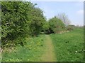
Former colliery railway - New Invention
The line between Sneyd and the canal wharf at Short Heath closed in the late 1960s. Typical of the area are unused parcels of land amongst the housing estates.
Image: © John M
Taken: 18 Apr 2009
0.04 miles
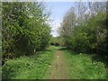
2
Former colliery railway - Short Heath
The line between Sneyd and the canal wharf at Short Heath closed in the late 1960s.
Image: © John M
Taken: 18 Apr 2009
0.12 miles
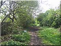
3
Former colliery railway - New Invention
The line between Sneyd and the canal wharf at Short Heath closed in the late 1960s.
Image: © John M
Taken: 18 Apr 2009
0.13 miles
4
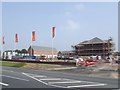
Squires Lock, New Invention
The former Squires Lock Works has recently been demolished to make way for flats and houses.
Image: © John M
Taken: 10 Jun 2007
0.19 miles
5
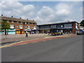
The Square - a small shopping parade
A collection of shops and small businesses (there's also a Co-op supermarket just off-shot to the left) on the Lichfield Road in New Invention.
Image: © Richard Law
Taken: 3 Aug 2011
0.20 miles
6
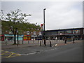
The Square, New Invention (1)
The Square is bordered on three sides by shops, with road access on the south side including car parking and a bus stop.
Image: © Richard Vince
Taken: 5 Jun 2013
0.20 miles
7
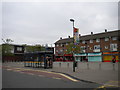
The Square, New Invention (2)
The Square is bordered on three sides by shops, with road access on the south side including car parking and this bus stop, from which one can catch buses to Bloxwich and Walsall. On Lichfield Road, opposite the square, buses leave from another bus stop for destinations including Willenhall and Wolverhampton.
Image: © Richard Vince
Taken: 5 Jun 2013
0.20 miles
8
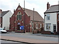
New Invention Methodist Church
Built in 1898 (according to the stone in the gable end), the church sits on the Lichfield Road
Image: © Richard Law
Taken: 3 Aug 2011
0.21 miles
9
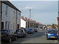
Coltham Road, Short Heath
Passing the Duke of Cambridge.
Image: © Richard Webb
Taken: 13 Apr 2016
0.22 miles
10
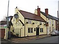
Duke of Cambridge (1), 82 Coltham Road, Shortheath, Willenhall
The pub closed in early 2008 following the death of the licensee. It re-opened on the 9th July 2009, having been acquired by the Black Country Ales micro-brewery of Lower Gornal. It has two bars plus a room with a pool table, which is available for functions. A wide range of real ales is carried both from Black Country Ales and many others.
Image
Image: © P L Chadwick
Taken: 29 Dec 2011
0.22 miles