IMAGES TAKEN NEAR TO
Longwood Rise, WILLENHALL, WV12 4AZ
Introduction
This page details the photographs taken nearby to Longwood Rise, WV12 4AZ by members of the Geograph project.
The Geograph project started in 2005 with the aim of publishing, organising and preserving representative images for every square kilometre of Great Britain, Ireland and the Isle of Man.

There are currently over 7.5m images from over14,400 individuals and you can help contribute to the project by visiting https://www.geograph.org.uk
Image Map
Images are licensed for reuse under creativecommons.org/licenses/by-sa/2.0
Notes
- Clicking on the map will re-center to the selected point.
- The higher the marker number, the further away the image location is from the centre of the postcode.
Image Listing (7 Images Found)
Images are licensed for reuse under creativecommons.org/licenses/by-sa/2.0
Image
Details
Distance
1
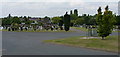
Willenhall Lawn Cemetery
Cemetery, Gardens of Remembrance, Chapel of Rest etc, all on the site here beside Bentley Lane
Image: © Richard Law
Taken: 3 Aug 2011
0.11 miles
2
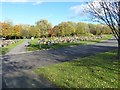
Willenhall Lawn Cemetery
The NE corner of this extensive cemetery.
Image: © Richard Law
Taken: 2 Nov 2012
0.12 miles
3
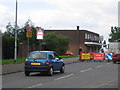
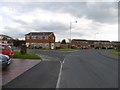
Shops and road works on Stroud Avenue, Willenhall
Image: © Angella Streluk
Taken: 22 Aug 2005
0.16 miles
6
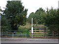
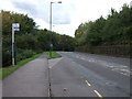
Footpath to Rough Wood Country Park
Off Bentley Lane.
Image: © JThomas
Taken: 5 Oct 2013
0.24 miles
7
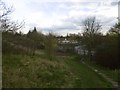
Mining landscape, Bentley Lane
The bings and scrub south of Rough Wood was landscaped as a golf course around 1990, but it never opened. It is now growing into woodland and becoming more alike Rough Wood itself over the canal.
Image: © Richard Webb
Taken: 13 Apr 2016
0.25 miles