IMAGES TAKEN NEAR TO
Boscobel Crescent, WOLVERHAMPTON, WV1 1QG
Introduction
This page details the photographs taken nearby to Boscobel Crescent, WV1 1QG by members of the Geograph project.
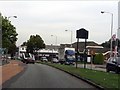
The Geograph project started in 2005 with the aim of publishing, organising and preserving representative images for every square kilometre of Great Britain, Ireland and the Isle of Man.

There are currently over 7.5m images from over14,400 individuals and you can help contribute to the project by visiting https://www.geograph.org.uk
Image Map
Images are licensed for reuse under creativecommons.org/licenses/by-sa/2.0
Notes
- Clicking on the map will re-center to the selected point.
- The higher the marker number, the further away the image location is from the centre of the postcode.
Image Listing (288 Images Found)
Images are licensed for reuse under creativecommons.org/licenses/by-sa/2.0
Image
Details
Distance
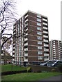
1
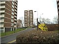
Stafford Street Flats
The view from the footpath to the flats on the 1960s Boscobel Estate in Wolverhampton.
Image: © Gordon Griffiths
Taken: 26 Jan 2015
0.01 miles
2
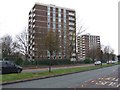
Council Housing - Boscobel Estate
Blocks of flats on the 1960s Boscobel Estate beside the Stafford Road.
Image: © John M
Taken: 14 Nov 2010
0.02 miles
3
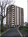
Council Housing -Tong Court
One of five blocks of flats on the 1960s Boscobel Estate.
Image: © John M
Taken: 14 Nov 2010
0.03 miles
4
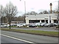
Jaguar Dealer
The view across Stafford Street in Wolverhampton to the Stratstone Dealership.
Image: © Gordon Griffiths
Taken: 26 Jan 2015
0.03 miles
5
Council Housing - Lane Court
One of five blocks of flats on the 1960s Boscobel Estate. The Lane family of Bentley Hall were instrumental in the escape of King Charles II in 1651 following defeat at the Battle of Worcester. The king hid in an oak tree at Boscobel House in Shropshire.
Image: © John M
Taken: 14 Nov 2010
0.04 miles
6
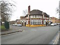
Hatherton Arms
The view of the Pub on the corner of Oxley Street and North Road in Wolverhampton.
Image: © Gordon Griffiths
Taken: 26 Jan 2015
0.05 miles
7
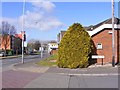
Bone Mill Lane View
The view down Stafford Street in Wolverhampton.
Image: © Gordon Griffiths
Taken: 4 Mar 2015
0.05 miles
8
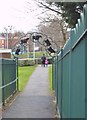
Cows over the Path
The view down the footpath to the flats on the 1960s Boscobel Estate from Stafford Street in Wolverhampton.
Image: © Gordon Griffiths
Taken: 26 Jan 2015
0.05 miles
10
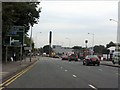
Stafford Street (A449) - Cannock Road junction
The A460 peels off, carrying traffic towards the M6 (junction 11) and A34 at Cannock.
Image: © J Whatley
Taken: 6 Sep 2010
0.07 miles