IMAGES TAKEN NEAR TO
Portchester Drive, WOLVERHAMPTON, WV11 3RQ
Introduction
This page details the photographs taken nearby to Portchester Drive, WV11 3RQ by members of the Geograph project.
The Geograph project started in 2005 with the aim of publishing, organising and preserving representative images for every square kilometre of Great Britain, Ireland and the Isle of Man.

There are currently over 7.5m images from over14,400 individuals and you can help contribute to the project by visiting https://www.geograph.org.uk
Image Map
Images are licensed for reuse under creativecommons.org/licenses/by-sa/2.0
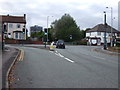
Notes
- Clicking on the map will re-center to the selected point.
- The higher the marker number, the further away the image location is from the centre of the postcode.
Image Listing (107 Images Found)
Images are licensed for reuse under creativecommons.org/licenses/by-sa/2.0
Image
Details
Distance
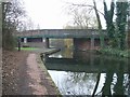
1
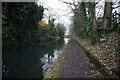
Wyrley & Essington Canal towards Wards Bridge
Image: © Ian S
Taken: 16 Dec 2021
0.06 miles
2
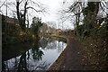
Wyrley & Essington Canal towards Wards Bridge
Image: © Ian S
Taken: 16 Dec 2021
0.06 miles
6
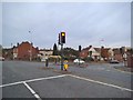
Neachells Lane Lights
The view of the junction with March End Road in Wednesfield.
Image: © Gordon Griffiths
Taken: 25 Oct 2015
0.08 miles
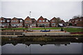
7
Wyrley & Essington Canal - Wednesfield Visitor Moorings
Close to the end of the High Street.
Image: © John M
Taken: 26 Dec 2006
0.09 miles
8
Halecroft Avenue
The view in Wednesfield.
Image: © Gordon Griffiths
Taken: 8 Aug 2015
0.10 miles
9
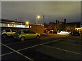
Wednesfield Con Club
The view of the Conservative Club at night on Neachells Lane in Wednesfield.
Image: © Gordon Griffiths
Taken: 5 Mar 2022
0.10 miles
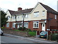
10
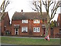
Council Housing - Pickering Road
The Pickering Road Estate is similar to other Wolverhampton overspill estates built in the mid 1950s in the neighbouring boroughs. The low brick walls are a feature shared with Long Knowle and Ashmore Park Estates.
Image: © John M
Taken: 22 Jan 2011
0.10 miles