IMAGES TAKEN NEAR TO
Merrick Road, WOLVERHAMPTON, WV11 3NU
Introduction
This page details the photographs taken nearby to Merrick Road, WV11 3NU by members of the Geograph project.
The Geograph project started in 2005 with the aim of publishing, organising and preserving representative images for every square kilometre of Great Britain, Ireland and the Isle of Man.

There are currently over 7.5m images from over14,400 individuals and you can help contribute to the project by visiting https://www.geograph.org.uk
Image Map
Images are licensed for reuse under creativecommons.org/licenses/by-sa/2.0
Notes
- Clicking on the map will re-center to the selected point.
- The higher the marker number, the further away the image location is from the centre of the postcode.
Image Listing (31 Images Found)
Images are licensed for reuse under creativecommons.org/licenses/by-sa/2.0
Image
Details
Distance
1
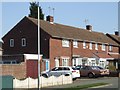
Council Housing - Merrick Road
Post war housing built for Wednesfield UDC on the early 1950s Castlebridge Estate.
Image: © John M
Taken: 19 Mar 2011
0.03 miles
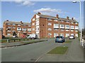
2
Flats on Ratcliffe Road, Perry Hall
A small low rise block, partially obscured by an inconvenient tree.
Image: © Richard Vince
Taken: 22 Sep 2017
0.07 miles
3
Junction of Merrick Road and Ratcliffe Road, Perry Hall
Image: © Richard Vince
Taken: 22 Sep 2017
0.07 miles
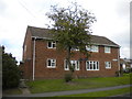
4
Council Housing - Castlebridge Estate
Wednesfield UDC developed the Castlebridge Estate in the early 1950s. This block comprises sixteen flats.
Image: © John M
Taken: 19 Mar 2011
0.08 miles
5
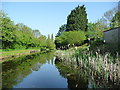
Overflow weir, Wyrley & Essington Canal
A row of slits in the concrete edging, under the towpath.
Image: © Christine Johnstone
Taken: 7 May 2018
0.09 miles
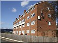
6
Council Housing - Castlebridge Estate
Wednesfield UDC developed the Castlebridge Estate in the early 1950s with a cluster of four storey blocks beside the Wyley & Essington Canal.
Image: © John M
Taken: 19 Mar 2011
0.09 miles
7
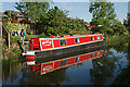
At the bottom of the garden
Local mooring on the Wyrley & Essington Canal
Image: © Row17
Taken: 7 May 2009
0.10 miles
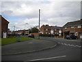
8
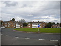
Approaching Stubby Lane roundabout, Perry Hall
Seen from the end of Perry Hall Road.
Image: © Richard Vince
Taken: 22 Sep 2017
0.10 miles
9
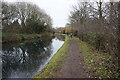
Wyrley & Essington Canal towards Perry Hall Bridge
Image: © Ian S
Taken: 16 Dec 2021
0.10 miles
10
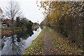
Wyrley & Essington Canal towards Perry Hill Bridge
Image: © Ian S
Taken: 16 Dec 2021
0.11 miles