IMAGES TAKEN NEAR TO
Worthy Down, WOLVERHAMPTON, WV11 3LY
Introduction
This page details the photographs taken nearby to Worthy Down, WV11 3LY by members of the Geograph project.
The Geograph project started in 2005 with the aim of publishing, organising and preserving representative images for every square kilometre of Great Britain, Ireland and the Isle of Man.

There are currently over 7.5m images from over14,400 individuals and you can help contribute to the project by visiting https://www.geograph.org.uk
Image Map
Images are licensed for reuse under creativecommons.org/licenses/by-sa/2.0
Notes
- Clicking on the map will re-center to the selected point.
- The higher the marker number, the further away the image location is from the centre of the postcode.
Image Listing (13 Images Found)
Images are licensed for reuse under creativecommons.org/licenses/by-sa/2.0
Image
Details
Distance
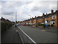
3
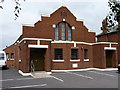
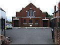
Wednesfield Christian Centre
Marked on the maps as a chapel, and still used as a place of worhsip, if only for 1 service a week on a Sunday evening. The sign outside also indicates an ongoing use for Marriages, Funerals and Infant Dedications "by arrangement".
Image: © Richard Law
Taken: 29 Jul 2010
0.20 miles
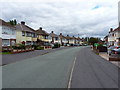
4
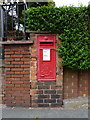
Edwardian wallbox outside the Wednesfield Christian Centre
I've seen a number of these north of Wolverhampton, but this is the first one I've come across in the Black Country. This one is WV11 204
Image: © Richard Law
Taken: 29 Jul 2010
0.20 miles
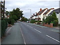
7
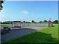
Colman Avenue, Perry Hall (1)
Seen from the junction with Perry Hall Road; the railings are there due to the presence of Perry Hall Primary School (out of frame to the left).
Image: © Richard Vince
Taken: 22 Sep 2017
0.22 miles
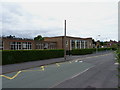
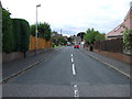
10
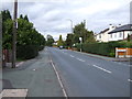
Broad Lane South, Wednesfield
Heading north east.
Image: © JThomas
Taken: 5 Oct 2013
0.22 miles