IMAGES TAKEN NEAR TO
Ferguson Street, WOLVERHAMPTON, WV11 2JU
Introduction
This page details the photographs taken nearby to Ferguson Street, WV11 2JU by members of the Geograph project.
The Geograph project started in 2005 with the aim of publishing, organising and preserving representative images for every square kilometre of Great Britain, Ireland and the Isle of Man.

There are currently over 7.5m images from over14,400 individuals and you can help contribute to the project by visiting https://www.geograph.org.uk
Image Map
Images are licensed for reuse under creativecommons.org/licenses/by-sa/2.0
Notes
- Clicking on the map will re-center to the selected point.
- The higher the marker number, the further away the image location is from the centre of the postcode.
Image Listing (16 Images Found)
Images are licensed for reuse under creativecommons.org/licenses/by-sa/2.0
Image
Details
Distance
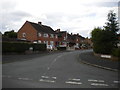
1
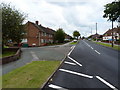
Griffiths Drive and Acorn Road, Ashmore Park area
Image: © Richard Law
Taken: 22 Jul 2011
0.04 miles
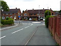
2
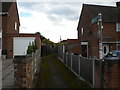
Public footpath to Ferguson Street, Ashmore Park
Seen from Griffiths Drive.
Image: © Richard Vince
Taken: 22 Sep 2017
0.05 miles
3
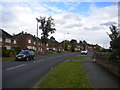
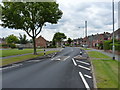
Northern part of Griffiths Drive, Ashmore Park
The main distributor road through the estate, forming a complete circuit that is traversed by the main bus route serving Ashmore Park.
Image: © Richard Vince
Taken: 22 Sep 2017
0.05 miles
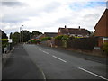
4
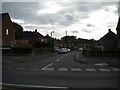
East end of Ferguson Street, Ashmore Park
Seen from Griffiths Drive.
Image: © Richard Vince
Taken: 22 Sep 2017
0.06 miles
5
Junction of Griffiths Drive and Barnard Road, Ashmore Park
Image: © Richard Law
Taken: 22 Jul 2011
0.08 miles
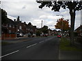
6
Rogers Close, Ashmore Park
Seen from Griffiths Drive.
Image: © Richard Vince
Taken: 22 Sep 2017
0.10 miles
7
North western part of Griffiths Drive, Ashmore Park
The main distributor road through the estate, forming a complete circuit that is traversed by the main bus route serving Ashmore Park.
Image: © Richard Vince
Taken: 22 Sep 2017
0.10 miles
8
Thornley Road joins Griffiths Drive, Ashmore Park
Image: © Richard Law
Taken: 22 Jul 2011
0.12 miles
9
South end of Millbank Street, Ashmore Park
Seen from Thornley Road.
Image: © Richard Vince
Taken: 22 Sep 2017
0.15 miles
10
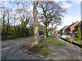
Kitchen Lane, Ashmore Park
The road predates the housing estate. There was a colliery here once, and a mineral line used to run behind the trees on the left.
Image: © Richard Webb
Taken: 13 Apr 2016
0.16 miles