IMAGES TAKEN NEAR TO
Ferndale Road, WOLVERHAMPTON, WV11 2JG
Introduction
This page details the photographs taken nearby to Ferndale Road, WV11 2JG by members of the Geograph project.
The Geograph project started in 2005 with the aim of publishing, organising and preserving representative images for every square kilometre of Great Britain, Ireland and the Isle of Man.

There are currently over 7.5m images from over14,400 individuals and you can help contribute to the project by visiting https://www.geograph.org.uk
Image Map
Images are licensed for reuse under creativecommons.org/licenses/by-sa/2.0
Notes
- Clicking on the map will re-center to the selected point.
- The higher the marker number, the further away the image location is from the centre of the postcode.
Image Listing (19 Images Found)
Images are licensed for reuse under creativecommons.org/licenses/by-sa/2.0
Image
Details
Distance

2
Forest of Mercia - Brownshore Lane
This land on the former Vernon Estate was given by the family to the people of Essington in 2000 in recognition of their connection with the village since 1547. The land was a previously used as a spoil tip for the nearby Essington Wood Colliery.
Image: © John M
Taken: 5 Apr 2009
0.17 miles
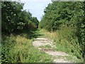
4
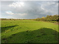
Footpath towards the motorways
Leading across a sunlit field, the footpath out of Essington here follows the hedgeline to a junction at the far end.
Image: © Richard Law
Taken: 6 Oct 2014
0.19 miles
5
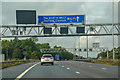
Junction 10a on the M6 Motorway northbound
Image: © Roy Hughes
Taken: 26 Aug 2024
0.20 miles
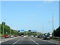
7
Essington : M6 Motorway
The M6 Motorway between Junction 10 (Walsall Interchange) and Junction 10A.
Image: © Lewis Clarke
Taken: 22 Sep 2019
0.20 miles
8
Wulfrun Way - Holly Bank Colliery Railway
The colliery site disappeared under the M54 in the 1980s and recent housing developments. The line here branched into loading sidings.
Image: © John M
Taken: 3 Sep 2006
0.21 miles
9
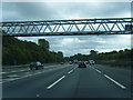
M6/M54 intersection
The gantries mark the point at which the M54 parts company with the M6, and heads west into Shropshire.
Image: © Richard Law
Taken: 6 Oct 2014
0.21 miles
10
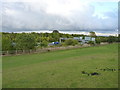
British. And apparently proud of it.
The owner of this field, with its grazing ponies, appears to be a proud Brit - he flies a Union flag from the pole on the hillock just ahead; it's visible from the M6 just off to the left.
Image: © Richard Law
Taken: 6 Oct 2014
0.22 miles