IMAGES TAKEN NEAR TO
High Hill, WOLVERHAMPTON, WV11 2DP
Introduction
This page details the photographs taken nearby to High Hill, WV11 2DP by members of the Geograph project.
The Geograph project started in 2005 with the aim of publishing, organising and preserving representative images for every square kilometre of Great Britain, Ireland and the Isle of Man.

There are currently over 7.5m images from over14,400 individuals and you can help contribute to the project by visiting https://www.geograph.org.uk
Image Map
Images are licensed for reuse under creativecommons.org/licenses/by-sa/2.0
Notes
- Clicking on the map will re-center to the selected point.
- The higher the marker number, the further away the image location is from the centre of the postcode.
Image Listing (6 Images Found)
Images are licensed for reuse under creativecommons.org/licenses/by-sa/2.0
Image
Details
Distance
1
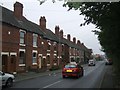
Jubilee and Victoria Cottages, Upper Sneyd Road
Late 1890s houses in the mining village of Essington. These properties were hemmed in on both sides by collieries. This is shown on maps as a 'twenty four house row'.
Image: © John M
Taken: 16 Sep 2006
0.18 miles
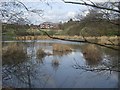
2
Forest of Mercia - Brownshore Lane
This land on the former Vernon Estate was given by the family to the people of Essington in 2000 in recognition of their connection with the village since 1547. The land was a previously used as a spoil tip for the nearby Essington Wood Colliery.
Image: © John M
Taken: 5 Apr 2009
0.20 miles
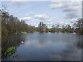
3
Fishing pool in the Forest of Mercia
On the fringe of the Forest of Mercia this land was formerly a colliery tip.
Image: © John M
Taken: 5 Apr 2009
0.22 miles
4
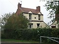
Rose Cottage, Upper Sneyd Road
1890s cottage tucked in behind the 'twenty four house row' of miners' housing.
Image: © John M
Taken: 16 Sep 2006
0.23 miles
5
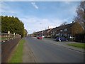
Kitchen Lane, Ashmore Park
Kitchen Lane predates Ashmore Park and once passed a colliery here. A path leaves the road here for Essington.
Image: © Richard Webb
Taken: 13 Apr 2016
0.23 miles
6
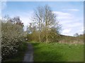
Ashmore Park to Essington path
Crossing a park/informal open space which shows signs of mining.
Image: © Richard Webb
Taken: 13 Apr 2016
0.24 miles