IMAGES TAKEN NEAR TO
Larchmere Drive, WOLVERHAMPTON, WV11 2DG
Introduction
This page details the photographs taken nearby to Larchmere Drive, WV11 2DG by members of the Geograph project.
The Geograph project started in 2005 with the aim of publishing, organising and preserving representative images for every square kilometre of Great Britain, Ireland and the Isle of Man.

There are currently over 7.5m images from over14,400 individuals and you can help contribute to the project by visiting https://www.geograph.org.uk
Image Map
Images are licensed for reuse under creativecommons.org/licenses/by-sa/2.0
Notes
- Clicking on the map will re-center to the selected point.
- The higher the marker number, the further away the image location is from the centre of the postcode.
Image Listing (18 Images Found)
Images are licensed for reuse under creativecommons.org/licenses/by-sa/2.0
Image
Details
Distance
1
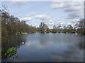
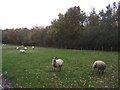
Forest of Mercia - Brownshore Lane
This land on the former Vernon Estate was given by the family to the people of Essington in 2000 in recognition of their connection with the village since 1547. The land was a previously used as a spoil tip for the nearby Essington Wood Colliery.
Image: © John M
Taken: 5 Apr 2009
0.14 miles
2
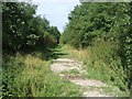
Wulfrun Way - Holly Bank Colliery Railway
The colliery site disappeared under the M54 in the 1980s and recent housing developments. The line here branched into loading sidings.
Image: © John M
Taken: 3 Sep 2006
0.15 miles
3
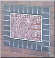
Essington Signal Box on Bursnips Road
A brief history of the signal box on a former colliery railway.
Image: © John M
Taken: 25 Aug 2006
0.17 miles
4
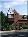
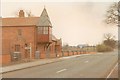
Bursnips Road Signal Box, Essington
The former signal box controlled the Holly Bank Colliery Railway level crossing on Bursnips Road. The line closed in 1969 with the demise of Hilton Main Colliery. The building was restored in 1991 and had lain derelict for some time Image
Image: © John M
Taken: 15 Sep 2006
0.17 miles

7
Crossing keeper's cottage at Bursnip Road
This building was originally the wages office and "truck shop" of the Holly Bank Colliery, which was served by a railway line which crossed the road on the level roughly where the footpath sign and driveway are. The rather fabulous signal box / crossing house is a later addition to the original building.
The house was derelict for years, and (to quote from Ned Williams's excellent "Railways of the Black Country", which is where most of the information in this caption is lifted from) "the building has just lasted into the 80s but has probably deteriorated beyond possible preservation." In early 1993, when I visited and took this, I was surprised and pleased to see that sympathetic reconstruction had just been completed. John M's Image shows the building as it appeared in 2006, 13 years after my visit; Tim Marshall's Image shows it as it was nine years before!
Image: © John Winder
Taken: Unknown
0.21 miles
8
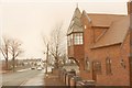
Bursnip Road crossing cottage and signal box
The line which served the collieries at Holly Bank and Hilton Main, on the northern edge of the Black Country, crossed Bursnip Road on the level at this point. The former wages office of Holly Bank colliery was adapted and became the crossing keeper's cottage and signal box. The building remains in use as a private house to this day: when this was taken, its renovation from a state of near - dereliction was just being completed.
Holly Bank Colliery stopped producing coal in 1927, but was retained until the late 1960s as a part of the drainage and ventilation systems at Hilton Main Colliery, to which it was linked by the old mine workings. The railway was dismantled by about 1970. When I visited in 1993 there were still some lengths of rail to be found rusting away in the undergrowth across the road.
Image: © John Winder
Taken: Unknown
0.21 miles
9
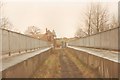
Bridge to Holly Bank Colliery
The railway which served Hilton Main and Holly Bank collieries survived long enough to inconvenience the builders of the M6 motorway, necessitating the building of the bridge I'm standing on here. The former crossing keeper's cottage and colliery wages office is visible in the centre of the shot. Holly Bank Colliery was to the right of the crossing keeper's cabin, roughly where the houses are on the skyline. The bridge now carries a footpath.
Image: © John Winder
Taken: Unknown
0.21 miles
10
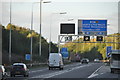
South Staffordshire : The M6 Motorway
The M6 Motorway heading through the South Staffordshire area and approaching junction 10a.
Image: © Lewis Clarke
Taken: 29 Oct 2013
0.21 miles