IMAGES TAKEN NEAR TO
Wood End Road, WOLVERHAMPTON, WV11 1YE
Introduction
This page details the photographs taken nearby to Wood End Road, WV11 1YE by members of the Geograph project.
The Geograph project started in 2005 with the aim of publishing, organising and preserving representative images for every square kilometre of Great Britain, Ireland and the Isle of Man.

There are currently over 7.5m images from over14,400 individuals and you can help contribute to the project by visiting https://www.geograph.org.uk
Image Map
Images are licensed for reuse under creativecommons.org/licenses/by-sa/2.0
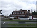
Notes
- Clicking on the map will re-center to the selected point.
- The higher the marker number, the further away the image location is from the centre of the postcode.
Image Listing (30 Images Found)
Images are licensed for reuse under creativecommons.org/licenses/by-sa/2.0
Image
Details
Distance
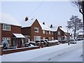
1
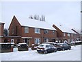
Council Housing - Bealey's Avenue
The Long Knowle Estate in Wednesfield was built in the early 1950s to house overspill from neighbouring Wolverhampton. Typical features are the low brick perimeter walls and brick walls between properties. Building started in October 1953 with the first 100 properties completed in August 1954.
Image: © John M
Taken: 19 Dec 2010
0.08 miles
2
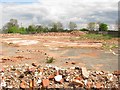
Demolished Wood Hayes /Old China Restaurant
The derelict 1950s pubImage hit by arson in June last year has finally been demolished to make way for a 69 bed nursing home.
Image: © John M
Taken: 16 May 2009
0.08 miles
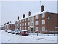
3
Council Housing - Guest Avenue - Rear of block
The rear yards of the properties have been improved on these 1950s flats on the Long Knowle Estate. The first of these three-storey blocks opened in June 1955.
Image: © John M
Taken: 19 Dec 2010
0.10 miles
4
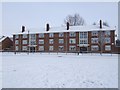
Council Housing - Bealey's Avenue
The Long Knowle Estate in Wednesfield was built in the early 1950s to house overspill from neighbouring Wolverhampton. The large blocks face onto a large grass area. The first of these three-storey blocks opened in June 1955.
Image: © John M
Taken: 19 Dec 2010
0.10 miles
5
The Wood Hayes (Old China Restaurant)
After a brief period as a Chinese Restaurant this 1950s pub closed about two years ago. Planning permission is being sought for a nursing home on this site. There are another three pub sites in Wolverhampton with similar applications.
The pub was finally demolished in May 2009.
Image: © John M
Taken: 21 Mar 2008
0.10 miles
6
Council Housing - Bealey's Avenue
The Long Knowle Estate in Wednesfield was built in the early 1950s to house overspill from neighbouring Wolverhampton. Typical features are the low brick perimeter walls and brick walls between properties. Building started in October 1953 with the first 100 properties completed in August 1954.
Image: © John M
Taken: 19 Dec 2010
0.10 miles
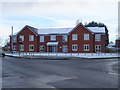
7
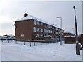
Council Housing - Guest Avenue
This early 1950s housing in Wednesfield was built as overspill for neighbouring Wolverhampton. Lack of available building land within the town led to agreement with the adjoining Urban Districts to develop new estates. The first of these three-storey blocks opened in June 1955. Some of these Districts were absorbed into the town with local government boundary changes in 1967.
Image: © John M
Taken: 19 Dec 2010
0.10 miles
8
Wood Hayes Place
Newly opened Bromford supported home development comprising fourteen self contained one bedroom apartments for adults with mental health conditions. The site was previously occupied by the 1950s Wood Hayes public house.
Image: © John M
Taken: 8 Dec 2017
0.10 miles
9
The Wood Hayes
Last time I passed by there was a pub here Image It was burnt down in 2008. Now demolished awaiting redevelopment.
Image: © Richard Webb
Taken: 1 May 2010
0.11 miles
10
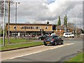
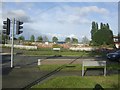
Shops, Blackhalve Lane
A 1960s shop and flat block on the crossroads where Blackhalve Lane meets Wood Hayes Road and Wood End Road.
Image: © Richard Webb
Taken: 1 May 2010
0.12 miles