IMAGES TAKEN NEAR TO
Wolverhampton Road, WOLVERHAMPTON, WV11 1UH
Introduction
This page details the photographs taken nearby to Wolverhampton Road, WV11 1UH by members of the Geograph project.
The Geograph project started in 2005 with the aim of publishing, organising and preserving representative images for every square kilometre of Great Britain, Ireland and the Isle of Man.

There are currently over 7.5m images from over14,400 individuals and you can help contribute to the project by visiting https://www.geograph.org.uk
Image Map
Images are licensed for reuse under creativecommons.org/licenses/by-sa/2.0
Notes
- Clicking on the map will re-center to the selected point.
- The higher the marker number, the further away the image location is from the centre of the postcode.
Image Listing (136 Images Found)
Images are licensed for reuse under creativecommons.org/licenses/by-sa/2.0
Image
Details
Distance
1
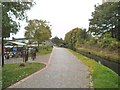
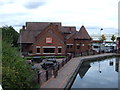
Canal Narrows
The view of the Wyrley and Essington Canal at Wednesfield.
Image: © Gordon Griffiths
Taken: 5 Oct 2015
0.03 miles
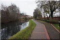
2
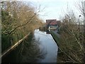
Wyrley and Essington Canal
A wide stretch of the Curly Wyrley between Heath Town and Wednesfield.
Image: © John M
Taken: 4 Feb 2007
0.03 miles
3
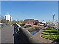
Former Bentley Canal
The roving bridge crosses the entrance to a former canal branch. All that is left is the water on the right that acts as moorings and extends to where the first lock was situated. There is a public house in the centre of the shot. The canal that the branch left is the Wyrley & Essington - also known as the "Curly Wyrley".
Image: © Chris Allen
Taken: 29 Mar 2019
0.04 miles
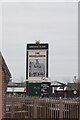
6

Bentley Arm
The bridge over the arm off the Wyrley and Essington Canal at Wednesfield.
Image: © Gordon Griffiths
Taken: 14 Apr 2013
0.04 miles
7
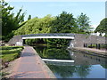
The Bentley Canal footbridge
A towpath bridge over the remaining very short stretch of what was originally the Bentley Canal branch, which led from the Wyrley and Essington cut through Willenhall towards Bentley Bridge, where it joined the Walsall Canal at Anson, as seen in Image The bridge itself will date from around 1843, the date at which the main line was opened, and was Grade II listed https://britishlistedbuildings.co.uk/101201908-footbridge-over-west-end-of-bentley-canal-wednesfield-south-ward#.W3Uao-hKhPY in 1992.
Image: © Richard Law
Taken: 19 Jul 2018
0.04 miles
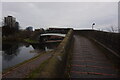
9
Wednesfield Junction, from the north-east
The towpath bridge crosses the now closed Bentley Canal. The narrows in the foreground are the site of a toll office.
Image: © Christine Johnstone
Taken: 7 May 2018
0.04 miles
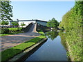
10
Wyrley & Essington Canal towards Rookery Bridge
Image: © Ian S
Taken: 16 Dec 2021
0.04 miles