IMAGES TAKEN NEAR TO
West Avenue, WOLVERHAMPTON, WV11 1PY
Introduction
This page details the photographs taken nearby to West Avenue, WV11 1PY by members of the Geograph project.
The Geograph project started in 2005 with the aim of publishing, organising and preserving representative images for every square kilometre of Great Britain, Ireland and the Isle of Man.

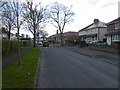
There are currently over 7.5m images from over14,400 individuals and you can help contribute to the project by visiting https://www.geograph.org.uk
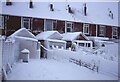
Image Map
Images are licensed for reuse under creativecommons.org/licenses/by-sa/2.0
Notes
- Clicking on the map will re-center to the selected point.
- The higher the marker number, the further away the image location is from the centre of the postcode.
Image Listing (44 Images Found)
Images are licensed for reuse under creativecommons.org/licenses/by-sa/2.0
Image
Details
Distance
1
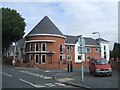
Bentley Court Nursing Home
The new home on the corner of Woden Avenue and Nordley Road will cater for dementia patients.
It is built on the site of the New Crown public house
Image: © John M
Taken: 31 Aug 2009
0.08 miles
2
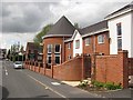
Bentley Court
New care home on the site of the not lamented New Crown pub. (possibly the worst pub I have ever visited).
Image: © Richard Webb
Taken: 1 May 2010
0.09 miles
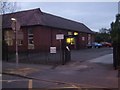
3
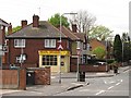
Nordley Road and Woden Avenue
Crossroads in Wednesfield with a carry out and corner shop (most corner shops seem to have disappeared around here). There was a pub opposite, but it has been replaced by a care home, not a sad loss in this case.
Image: © Richard Webb
Taken: 1 May 2010
0.11 miles
4
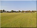
Playing Field Games
The view in the King George V Memorial Park, Wednesfield.
Image: © Gordon Griffiths
Taken: 4 Oct 2015
0.12 miles
5
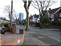
Vicarage Road, Wednesfield
Tree lined residential street, although infamously one of the trees did once end up in somebody's house. The flats are now blue.
Image: © Richard Webb
Taken: 13 Apr 2016
0.13 miles
6
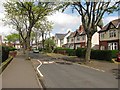
Vicarage Road in Spring
The southern part of the street has large detached or semi detached houses while around the corner is a mix of old council stock and 1890s terraces. At least one of these terraces is rather damp.
The trees have mostly survived despite fears of root damage when cable TV was installed in the early 1990's. There was one about where I was standing, but it fell victim to a storm.
Image: © Richard Webb
Taken: 1 May 2010
0.13 miles
7
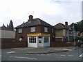
Pearl Dragon Takeaway
Chinese takeaway on the corner of Nordley Road and Frederick Road. The 'New Crown' on the opposing corner was demolished in 2008 and has been replaced by a nursing home.
Image: © John M
Taken: 31 Aug 2009
0.13 miles
8
Back of a terrace, Vicarage Road, Wednesfield
Image: © Richard Webb
Taken: Unknown
0.14 miles
9
Polling Station - Wolverhampton North East
Wodensfelde Primary School plays host to a polling station for the 2010 General Election. The school is in a post war Council Estate many of the houses have been purchased under 'Right to Buy' schemes. The demographic is working class.
Image: © John M
Taken: 6 May 2010
0.14 miles