IMAGES TAKEN NEAR TO
Mammoth Drive, Wolverhampton Science Park, WOLVERHAMPTON, WV10 9TF
Introduction
This page details the photographs taken nearby to Mammoth Drive, Wolverhampton Science Park, WV10 9TF by members of the Geograph project.
The Geograph project started in 2005 with the aim of publishing, organising and preserving representative images for every square kilometre of Great Britain, Ireland and the Isle of Man.

There are currently over 7.5m images from over14,400 individuals and you can help contribute to the project by visiting https://www.geograph.org.uk
Image Map
Images are licensed for reuse under creativecommons.org/licenses/by-sa/2.0
Notes
- Clicking on the map will re-center to the selected point.
- The higher the marker number, the further away the image location is from the centre of the postcode.
Image Listing (48 Images Found)
Images are licensed for reuse under creativecommons.org/licenses/by-sa/2.0
Image
Details
Distance
4
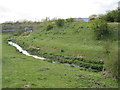
Brook and mound north of Fowlers Park, Wolverhampton
Rough ground north of Fowlers Park close to travellers' site.
Image: © Terry Cooper
Taken: 13 Apr 2019
0.11 miles
5
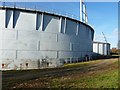
Twin gas holders, Dunstall
Two large 'gasometers' on the site of the former Dunstall gasworks, just off the A449 Stafford Road. This was once the site of the Wolverhampton Gas Company, which became nationalised in 1949 and was duly replaced by the West Midlands Gas Board. http://blackcountryhistory.org/collections/getrecord/GB149_P_6103/
Image: © Richard Law
Taken: 24 Nov 2010
0.11 miles
6
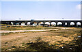
Viaduct on Stour Valley Line, 1980
The viaduct as seen from the tow path of the Birmingham Canal in the vicinity of locks 13 and 14 of the Wolverhampton flight. Notes made at the time, April 1980, record that the waste ground was the site of a gas works. Two gasometers can be seen beyond the arches of the viaduct and still seem to be in place over 40 years later. The site is now occupied by a science park.
Image: © Trevor Littlewood
Taken: 4 Apr 1980
0.14 miles
7
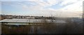
Sherwood View
The view from Showell Road in Oxley, Wolverhampton.
Image: © Gordon Griffiths
Taken: 3 Jun 2024
0.14 miles
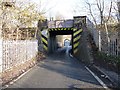
8
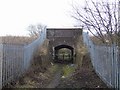
Under the railway
An uninviting footpath leading towards Fowler's Fields.
Image: © John M
Taken: 23 Feb 2008
0.15 miles
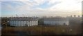
9

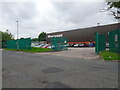
University of Wolverhampton Science Park
Image: © Andrew Abbott
Taken: 2 Feb 2023
0.17 miles
10
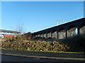
Viaduct View
Dubstall Viaduct viewed from Coxwell Avenue.
Image: © Gordon Griffiths
Taken: 30 Jan 2008
0.18 miles