IMAGES TAKEN NEAR TO
Byron Road, WOLVERHAMPTON, WV10 8SH
Introduction
This page details the photographs taken nearby to Byron Road, WV10 8SH by members of the Geograph project.
The Geograph project started in 2005 with the aim of publishing, organising and preserving representative images for every square kilometre of Great Britain, Ireland and the Isle of Man.

There are currently over 7.5m images from over14,400 individuals and you can help contribute to the project by visiting https://www.geograph.org.uk
Image Map
Images are licensed for reuse under creativecommons.org/licenses/by-sa/2.0
Notes
- Clicking on the map will re-center to the selected point.
- The higher the marker number, the further away the image location is from the centre of the postcode.
Image Listing (45 Images Found)
Images are licensed for reuse under creativecommons.org/licenses/by-sa/2.0
Image
Details
Distance
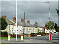
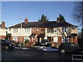
1
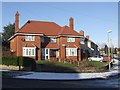
Council Housing - Newman Road
Large semi-detached house on a corner plot on the 1937 Scotlands Estate.
Image: © John M
Taken: 20 Dec 2009
0.07 miles
2
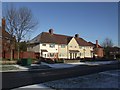
Council Housing - Masefield Road
Evidence here of a Council house sale on the 1937 Scotlands Estate. The nearest property was excluded from the latest modernisation and re-roofing works.
Image: © John M
Taken: 20 Dec 2009
0.09 miles
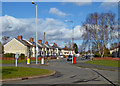
4
Ruskin Road in Old Fallings, Wolverhampton
This shows Ruskin Road, looking north-east from the roundabout by Old Fallings Lane.
Image: © Roger D Kidd
Taken: 8 Mar 2018
0.15 miles
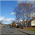
5
Housing in Ruskin Road, Old Fallings, Wolverhampton
Semi-detached freehold houses seen from Old Fallings Lane near the roundabout.
Image: © Roger D Kidd
Taken: 10 Oct 2013
0.17 miles
6
Ruskin Road in Old Fallings, Wolverhampton
This shows Ruskin Road, looking north-east from the roundabout by Old Fallings Lane.
Image: © Roger D Kidd
Taken: 8 Mar 2018
0.18 miles
7
Housing in Ruskin Road, Old Fallings, Wolverhampton
This shows semi-detached houses in Ruskin Road, looking north-east from the roundabout by Old Fallings Lane.
Image: © Roger D Kidd
Taken: 8 Mar 2018
0.18 miles
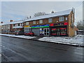
8
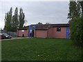
Polling Station - Wolverhampton North East
Polling station for the 2010 General Election at the Scotlands Adventure Playground. The polling station serves a 1930s Council Estate with some houses bought under 'Right to Buy' schemes. The demographic is working class with social deprivation and high unemployment.
Image: © John M
Taken: 6 May 2010
0.18 miles
9
Council Housing - Chesterton Road
The houses on the Scotlands Estate were completed in 1937. The roads are named after poets and writers, Pope, Dickens, Keats etc.
Image: © John M
Taken: 20 Dec 2009
0.19 miles
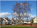
10
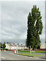
Poplar tree and Ruskin Road in Old Fallings, Wolverhampton
Looking across the junction of Old Fallings Lane with Primrose Lane.
Note: The tree has been felled. I only noticed in 2018.
Image: © Roger D Kidd
Taken: 10 Oct 2013
0.19 miles