IMAGES TAKEN NEAR TO
Cannock Road, WOLVERHAMPTON, WV10 8QS
Introduction
This page details the photographs taken nearby to Cannock Road, WV10 8QS by members of the Geograph project.
The Geograph project started in 2005 with the aim of publishing, organising and preserving representative images for every square kilometre of Great Britain, Ireland and the Isle of Man.

There are currently over 7.5m images from over14,400 individuals and you can help contribute to the project by visiting https://www.geograph.org.uk
Image Map
Images are licensed for reuse under creativecommons.org/licenses/by-sa/2.0
Notes
- Clicking on the map will re-center to the selected point.
- The higher the marker number, the further away the image location is from the centre of the postcode.
Image Listing (28 Images Found)
Images are licensed for reuse under creativecommons.org/licenses/by-sa/2.0
Image
Details
Distance
1
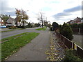
Cannock Road Scene
The view from the Monarch's Way at Westcroft as it crosses the A460.
Image: © Gordon Griffiths
Taken: 4 Nov 2021
0.02 miles
2
Monarch's Way and Wulfrun Way
The footpaths cross the Cannock Road on their way to Essington. The Monarch's Way is a long distance footpath between Worcester and Shoreham. The Wulfrun Way is a new 15 mile footpath promoted by Staffordshire Council linking the edge of Wolverhampton and Chasewater linking disused colliery railways and canals.
Image: © John M
Taken: 6 Apr 2008
0.03 miles
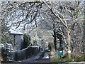
3

Wulfrun Way
The footpath leaves the Cannock Road and joins the Monarch's Way at Westcroft heading towards Bushbury.
Image: © Gordon Griffiths
Taken: 12 Sep 2009
0.03 miles
4

Cannock Road
The view from the Monarch's Way at Westcroft as it crosses the A460.
Image: © Gordon Griffiths
Taken: 12 Sep 2009
0.06 miles
5
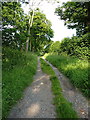
Bridleway from Northycote Park to Westcroft
Image: © Richard Law
Taken: 18 Jun 2014
0.08 miles
6
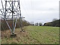
Pylon View
The view from the Monarch's Way near Wolverhampton.
Image: © Gordon Griffiths
Taken: 3 Feb 2020
0.12 miles
7
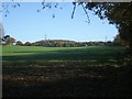
Grazing land rising towards Westcroft
The rising ground up to the ribbon development on the A460 continues onwards in the direction of Essington.
Image: © John M
Taken: 19 Nov 2006
0.13 miles
8
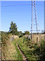
Path under the Pylons
The Monarch's Way at Westcroft heading towards Essington.
Image: © Gordon Griffiths
Taken: 12 Sep 2009
0.14 miles
9

Monarch's Way View
The Monarch's Way at Westcroft heading towards the A460 (Cannock Road).
Image: © Gordon Griffiths
Taken: 12 Sep 2009
0.15 miles
10
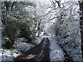
Monarch's Way
Leaving Northycote Farm the footpath crosses a stream and climbs to meet the Cannock Road at Westcroft.
Image: © John M
Taken: 6 Apr 2008
0.17 miles