IMAGES TAKEN NEAR TO
Wood Hayes Croft, WOLVERHAMPTON, WV10 8PP
Introduction
This page details the photographs taken nearby to Wood Hayes Croft, WV10 8PP by members of the Geograph project.
The Geograph project started in 2005 with the aim of publishing, organising and preserving representative images for every square kilometre of Great Britain, Ireland and the Isle of Man.

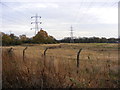
There are currently over 7.5m images from over14,400 individuals and you can help contribute to the project by visiting https://www.geograph.org.uk
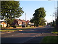
Image Map
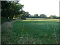
Images are licensed for reuse under creativecommons.org/licenses/by-sa/2.0
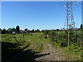
Notes
- Clicking on the map will re-center to the selected point.
- The higher the marker number, the further away the image location is from the centre of the postcode.
Image Listing (27 Images Found)
Images are licensed for reuse under creativecommons.org/licenses/by-sa/2.0
Image
Details
Distance
1
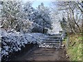
Gated road in winter
Old Hampton Lane is gated off at both ends. There were no properties on the road which I understand was closed as a result of mining subsidence.
Image: © John M
Taken: 6 Apr 2008
0.03 miles
2
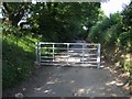
Gated Road
Old Hampton Lane is gated off at both ends, although there is no lock. There were no properties on the road which I understand was closed as a result of mining subsidence.
Image: © John M
Taken: 10 Jun 2007
0.04 miles
3
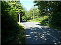
At the crossroads of Wood Hayes Road and Old Hampton Lane
Image: © Richard Law
Taken: 7 Sep 2012
0.05 miles
4
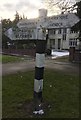
Old Direction Sign - Signpost by the A460, Cannock Road, Underhill
Pyramid top finial - 3 arms; Cannock RDC wooden by the A460, in parish of Featherstone (South Staffordshire District), Cannock Road, Westcroft, opposite junction with Wood Hayes Road.
Surveyed
Milestone Society National ID: ST_SJ9302A
Image: © Milestone Society
Taken: Unknown
0.06 miles
5
The backs of houses on the A460
A field and pylons behind the houses that line the A460 Cannock Road between Underhill and Westcroft.
Image: © Richard Law
Taken: 7 Sep 2012
0.08 miles
6
Cannock Road, Westcroft, Wolverhampton
Ribbon development along the A460 northeast of Wolverhampton. There's open country a few yards away on either side. From the junction with Wood Hayes Road.
Image: © Derek Harper
Taken: 18 Jul 2006
0.08 miles
7
Field by Wood Hayes Road
This field, gently sloping to the right, is actually part of the same field shown in Image Wood Hayes Road is on the left.
Image: © Derek Harper
Taken: 18 Jul 2006
0.09 miles
8
Pylon View
The view from the Dismantled Railway line near Westcroft in Wolverhampton.
Image: © Gordon Griffiths
Taken: 28 Nov 2011
0.12 miles
9
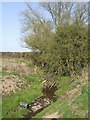
Waterhead Brook upstream towards Wood Hayes Road
The brook, a tributary of the River Penk, flows through farmland from its source near Essington. This is typical of the fly tipping that is found as it passes around the edge of the conurbation.
Image: © John M
Taken: 17 Apr 2010
0.13 miles
10

Waterhead Brook Bridge in Wood Hayes Road
The Wolverhampton/Staffordshire boundary follows the centre of the brook. The joint in the road surfacing reflects this.
Image: © John M
Taken: 17 Apr 2010
0.13 miles