IMAGES TAKEN NEAR TO
Greenacres Avenue, WOLVERHAMPTON, WV10 8NZ
Introduction
This page details the photographs taken nearby to Greenacres Avenue, WV10 8NZ by members of the Geograph project.
The Geograph project started in 2005 with the aim of publishing, organising and preserving representative images for every square kilometre of Great Britain, Ireland and the Isle of Man.

There are currently over 7.5m images from over14,400 individuals and you can help contribute to the project by visiting https://www.geograph.org.uk
Image Map
Images are licensed for reuse under creativecommons.org/licenses/by-sa/2.0
Notes
- Clicking on the map will re-center to the selected point.
- The higher the marker number, the further away the image location is from the centre of the postcode.
Image Listing (52 Images Found)
Images are licensed for reuse under creativecommons.org/licenses/by-sa/2.0
Image
Details
Distance
1
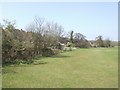
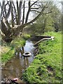
Course of Waterhead Brook - Underhill
Housing in Waterhead Drive backs on to the brook. The brook marks the city boundary with green belt here on the Staffordshire side.
Image: © John M
Taken: 17 Apr 2010
0.05 miles
2
Polling Station - Wolverhampton North East
Polling station for the 2010 General Election at Berry Brook Junior School. The school is on the edge of a late 1950s Council Estate with a number of properties sold under 'Right to Buy' schemes. The local issue here was the recent closure of the council run Underhill House Care Home. The demographic is relatively unskilled working class with some owner occupiers.
Image: © John M
Taken: 6 May 2010
0.07 miles
3

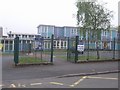
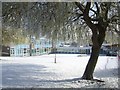
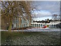
Berry Brook Primary School
I assume that the school had a change of name from Underhill Primary when it got the paint job.
Image: © John M
Taken: 3 Feb 2007
0.07 miles
5
Berry Brook Primary School
Pristine snow on an early April Sunday morning.
Image: © John M
Taken: 6 Apr 2008
0.08 miles
6
Waterhead Brook upstream at Waterhead Drive
Typical fly tipping in the brook which marks the Wolverhampton city boundary. This was also known as the Berry Brook and the local school now shares this name.
Image: © John M
Taken: 17 Apr 2010
0.09 miles
7
Berry Brook Primary School at Christmas
The former Underhill Primary School is closed for the Christmas holidays.
Image: © John M
Taken: 20 Dec 2009
0.09 miles
8
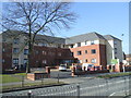
Wulfrun Rose Nursing Home
A privately run Care Home on the site of Underhill House opened in February 2016.
Image: © John M
Taken: 13 Mar 2016
0.09 miles
9
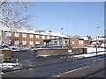
Underhill House
Council operated home recently reprieved from closure after review.
The reprieve was relatively short-lived as the home closed in January 2010 amidst some uproar as 106 year old Louisa Watts was moved to another home on one of the coldest days of the winter.
A new private care home opened on the site in February 2016.
Image: © John M
Taken: 6 Apr 2008
0.10 miles
10
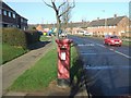
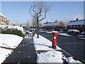
Post war council housing on Underhill Estate
The George VI postbox on Underhill Lane is contemporary with the housing. A large proportion of this housing has transferred into private ownership under 'right to buy'. The housing on the right hand side of the road was built in the late 1940s and is some of the earliest post-war housing in the town. The housing on the left dates from a few years later.
Image: © John M
Taken: 3 Feb 2007
0.12 miles