IMAGES TAKEN NEAR TO
Waterhead Close, WOLVERHAMPTON, WV10 8NX
Introduction
This page details the photographs taken nearby to Waterhead Close, WV10 8NX by members of the Geograph project.
The Geograph project started in 2005 with the aim of publishing, organising and preserving representative images for every square kilometre of Great Britain, Ireland and the Isle of Man.

There are currently over 7.5m images from over14,400 individuals and you can help contribute to the project by visiting https://www.geograph.org.uk
Image Map
Images are licensed for reuse under creativecommons.org/licenses/by-sa/2.0
Notes
- Clicking on the map will re-center to the selected point.
- The higher the marker number, the further away the image location is from the centre of the postcode.
Image Listing (27 Images Found)
Images are licensed for reuse under creativecommons.org/licenses/by-sa/2.0
Image
Details
Distance
1
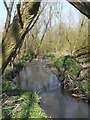
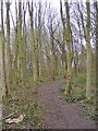
Waterhead Brook entering the Country Park
Neglected watercourse in the woods choked with rubbish.
Image: © John M
Taken: 17 Apr 2010
0.06 miles
2
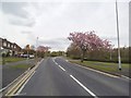
Underhill Lane
The view in Bushbury, Wolverhampton.
Image: © Gordon Griffiths
Taken: 1 May 2015
0.07 miles
3
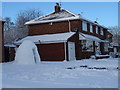
Council Housing - Underhill Lane
Walk-in igloo on the 1950s Underhill Estate.
Image: © John M
Taken: 11 Dec 2017
0.08 miles
4
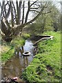
Waterhead Brook upstream at Waterhead Drive
Typical fly tipping in the brook which marks the Wolverhampton city boundary. This was also known as the Berry Brook and the local school now shares this name.
Image: © John M
Taken: 17 Apr 2010
0.08 miles
5
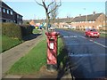
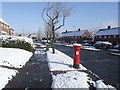
Post war council housing on Underhill Estate
The George VI postbox on Underhill Lane is contemporary with the housing. A large proportion of this housing has transferred into private ownership under 'right to buy'. The housing on the right hand side of the road was built in the late 1940s and is some of the earliest post-war housing in the town. The housing on the left dates from a few years later.
Image: © John M
Taken: 3 Feb 2007
0.08 miles
6
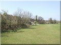
North Wood
The view in Northicote Farm Country Park, Wolverhampton.
Image: © Gordon Griffiths
Taken: 1 Apr 2017
0.10 miles
7
Course of Waterhead Brook - Underhill
Housing in Waterhead Drive backs on to the brook. The brook marks the city boundary with green belt here on the Staffordshire side.
Image: © John M
Taken: 17 Apr 2010
0.11 miles
8
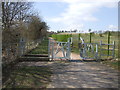
Footpath to Bushbury Hill
Diverted footpath avoiding the recent extension to Bushbury Crematorium.
Image: © John M
Taken: 6 Apr 2013
0.11 miles
10
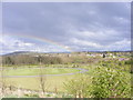
Bushbury Rainbow
The view from the slopes of Bushbury Hill over the extension to Bushbury Crematorium.
Image: © Gordon Griffiths
Taken: 1 Apr 2017
0.18 miles