IMAGES TAKEN NEAR TO
Northwood Park Road, WOLVERHAMPTON, WV10 8EW
Introduction
This page details the photographs taken nearby to Northwood Park Road, WV10 8EW by members of the Geograph project.
The Geograph project started in 2005 with the aim of publishing, organising and preserving representative images for every square kilometre of Great Britain, Ireland and the Isle of Man.

There are currently over 7.5m images from over14,400 individuals and you can help contribute to the project by visiting https://www.geograph.org.uk
Image Map
Images are licensed for reuse under creativecommons.org/licenses/by-sa/2.0
Notes
- Clicking on the map will re-center to the selected point.
- The higher the marker number, the further away the image location is from the centre of the postcode.
Image Listing (9 Images Found)
Images are licensed for reuse under creativecommons.org/licenses/by-sa/2.0
Image
Details
Distance
1
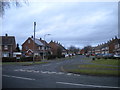
South end of Egerton Road, Northwood Park
Seen from Northwood Park Road.
Image: © Richard Vince
Taken: 24 Dec 2017
0.02 miles
2
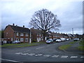
West end of Pendrill Road, Northwood Park
Seen from Northwood Park Road.
Image: © Richard Vince
Taken: 24 Dec 2017
0.03 miles
3
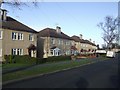
Council Housing - Wentworth Road
A concrete design probably dating from around 1950.
Image: © John M
Taken: 6 Dec 2009
0.12 miles
4
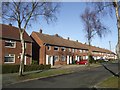
Council Housing - Wentworth Road
Brick built block of four dwellings from early 1950s.
Image: © John M
Taken: 6 Dec 2009
0.13 miles
5
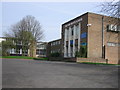
The Northicote High School
This school is now surrounded by a high metal fence. It used to be surrounded by a large open area.
Image: © Angella Streluk
Taken: 22 Apr 2006
0.19 miles
6
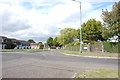
Legs Lane from Northycote Lane, Fordhouses
Image: © Mick Malpass
Taken: 10 Sep 2011
0.21 miles
7
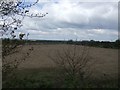
Former School Playing Fields
The school fields associated with Northycote School have not been used for many years and the grass is knee high. This would be a prime site for housing development but is probably safe as it abuts the Green Belt, Crematorium and Northicote Farm Country Park.
Image: © John M
Taken: 3 May 2010
0.22 miles
8
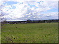
Bushbury Field
The view from Bushbury Lane, Wolverhampton.
Image: © Gordon Griffiths
Taken: 1 Apr 2017
0.22 miles
9
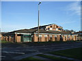
Time is running out for The King Charles
Marston's Brewery announced this week that they would be creating 1250 jobs in their 25 new pub restaurants to be opened next year. As their business model has changed to focus on food there is no longer a place for their large estate of tenanted locals many formerly trading under the original Banks's name. Marston's disposed of 388 pubs last year with a further 200 to go this year. The King Charles will be replaced by housing.
For a view as a going business see Image
Image: © John M
Taken: 6 Dec 2014
0.25 miles