IMAGES TAKEN NEAR TO
St. Chads Road, WOLVERHAMPTON, WV10 8BS
Introduction
This page details the photographs taken nearby to St. Chads Road, WV10 8BS by members of the Geograph project.
The Geograph project started in 2005 with the aim of publishing, organising and preserving representative images for every square kilometre of Great Britain, Ireland and the Isle of Man.

There are currently over 7.5m images from over14,400 individuals and you can help contribute to the project by visiting https://www.geograph.org.uk
Image Map
Images are licensed for reuse under creativecommons.org/licenses/by-sa/2.0
Notes
- Clicking on the map will re-center to the selected point.
- The higher the marker number, the further away the image location is from the centre of the postcode.
Image Listing (60 Images Found)
Images are licensed for reuse under creativecommons.org/licenses/by-sa/2.0
Image
Details
Distance
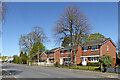
1
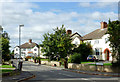
St Chad's Road in Oldfallings, Wolverhampton
A short cul-de-sac off Old Fallings Lane with semi-detached freehold houses. Sadly, it seems the authority has seen fit to drop the apostrophe, while insisting that its correct use is taught in its schools.
Image: © Roger D Kidd
Taken: 10 Oct 2013
0.01 miles
2
St Chads Road in Old Fallings, Wolverhampton
The short Cul-de-sac off Old Fallings Lane dispenses with the apostrophe (presumably) taught at the nearby Our Lady and St Chad Catholic Academy.
Image: © Roger Kidd
Taken: 22 Apr 2021
0.01 miles
3
St Chads Road in Oldfallings, Wolverhampton
St Chads (sic) Road is a short cul-de-sac off Old Fallings Lane. The council would have reprimanded me if Ofsted had reported me for poor teaching of correct apostrophe usage. http://www.geograph.org.uk/photo/3696873
Image: © Roger D Kidd
Taken: 8 Mar 2018
0.01 miles
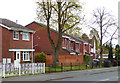
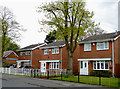
4
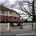
Care home in Old Fallings, Wolverhampton
This residential care home can accommodate up to 48 elderly people.
Image: © Roger D Kidd
Taken: 30 Apr 2015
0.03 miles
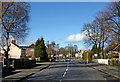
5
Old Fallings Lane near Low Hill, Wolverhampton
Looking north-north-west by the Primrose Hill Care Home.
Image: © Roger Kidd
Taken: 22 Apr 2021
0.04 miles
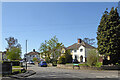
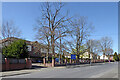
6
Old Fallings Lane east of Low Hill, Wolverhampton
This is Old Fallings Lane (in Old Fallings!) looking north towards the junction with St Chad's Road.
Image: © Roger D Kidd
Taken: 8 Mar 2018
0.04 miles
7
Housing in Old Fallings Lane, Wolverhampton
Recently built homes near the roundabout junction with Primrose Lane.
Image: © Roger D Kidd
Taken: 30 Apr 2015
0.04 miles
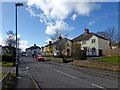
8
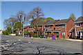
Housing in Old Fallings Lane near Low Hill, Wolverhampton
Looking north towards the roundabout by Primrose Lane. The hideous purple "garden wast" bins await emptying. When the council decided to charge £35 per year for collecting garden waste, they decided to abandon the previous sensible green bins, and instead of getting a "discreet" colour chose this, causing eyesores all over the city!
Image: © Roger Kidd
Taken: 22 Apr 2021
0.04 miles
9
Housing in Old Fallings Lane near Low Hill, Wolverhampton
Looking north towards the roundabout by Primrose Lane.
Image: © Roger Kidd
Taken: 22 Apr 2021
0.05 miles
10
Housing in Old Fallings Lane, Wolverhampton
Recently built homes near the roundabout junction with Primrose Lane. Most of the housing nearby is from the 1920s-1930s era.
Image: © Roger D Kidd
Taken: 30 Apr 2015
0.05 miles